Bol’shoy Karay geodata
Bol’shoy Karay (Saratovskaya Oblast) is a populated place; located in Russia in Europe/Saratov (GMT+4) time zone. With population of 2,180 people, there are 4081 cities with bigger population in this country. Compared to other cities in Russia, 71.9% of cities are located further ↑North; 57.9% of cities are located further →East and 57.8% of cities have lower elevation than Bol’shoy Karay. Note1


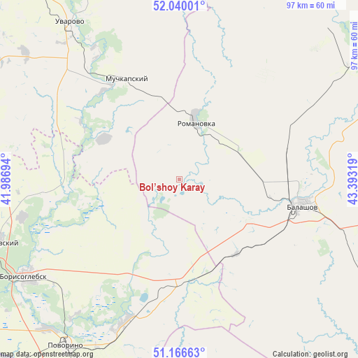
Bol’shoy Karay GPS coordinates[2]
51° 36' 19.512" North, 42° 41' 24.216" East
| Map corner | latitude | longitude |
|---|---|---|
| Upper-left | 52.04001°, | 41.98694° |
| Center: | 51.60542°, | 42.69006° |
| Lower-right: | 51.16663°, | 43.39319° |
| Map W x H: | 97.1×97.1 km | = 60.3×60.3mi |
| max Lat: | 73.50819° ⇑71.9% North |
| Bol’shoy Karay: | 51.60542° |
| min Lat: | ⇓28.1% South 41.28413° |
| min Long | Bol’shoy Kara | max Long |
| -179.12198° | 42.69006° | 179.35046° |
| W 42.1%⇐ | ⇒57.9% E |
Elevation
Elevation of Bol’shoy Karay is 163 m = 535 ft, and this is 39.6 m = 130 ft below average elevation for this country.
| Max E: |
2518 m = 8261 ft | 42.2% |
| Avg. | 202.6 m = 665 ft | |
| Bol’shoy Karay | 163 m = 535 ft | |
Min E: |
-28 m = -92 ft | 57.8% |
See also: Russia elevation on elevation.city.
Geographical zone
Bol’shoy Karay is located in North temperate zone (between Tropic of Cancer and the Arctic Circle). Distance of this North polar circle is 1663.2 km =1033.5 mi to North.| Distance of | km | miles | from Bol’shoy Karay |
|---|---|---|---|
| North Pole | 4269.1 | 2652.7 | to North |
| Arctic Circle | 1663.2 | 1033.5 | to North |
| Tropic Cancer | 3132.1 | 1946.2 | to South |
| Equator | 5738 | 3565.4 | to South |


Nearby cities:
15 places around Bol’shoy Karay: (largest is in red/bold)
• Arkadak
66.4 km =41.3 mi,  56°
56°
• Balashov
33.5 km =20.8 mi,  100°
100°
• Borisoglebsk
49.6 km =30.8 mi,  237°
237°
• Gribanovskiy
52 km =32.3 mi,  251°
251°
• Kamenka
31.9 km =19.8 mi,  170°
170°
• Muchkapskiy
31.2 km =19.4 mi,  331°
331°
• Novonikolayevskiy
73.8 km =45.9 mi,  197°
197°
• Pinerovka
26.6 km =16.5 mi, 100°
• Povorino
55.1 km =34.2 mi,  214°
214°
• Repnoye
34.3 km =21.3 mi,  92°
92°
• Romanovka
16 km =9.9 mi,  15°
15°
• Rzhaksa
74.4 km =46.2 mi,  322°
322°
• Ternovka
73.1 km =45.4 mi,  276°
276°
• Turki
58.4 km =36.3 mi,  43°
43°
• Uvarovo
51.5 km =32 mi, 325°
Sources, notices
• [Note1] Compared only with cities in Russia existing in our database
• [Src1] Map data: © OpenStreetMap contributors (CC-BY-SA)
• [Src2] Other city data from geonames.org with taken over terms of usage.
• [Src3] Geographical zone / Annual Mean Temperature by Robert A. Rohde @ Wikipedia
