Uvarovo geodata
Uvarovo (Tambov) is a populated place; located in Russia in Europe/Moscow (GMT+3) time zone. With population of 28,771 people, there are 681 cities with bigger population in this country. Compared to other cities in Russia, 69.3% of cities are located further ↑North; 58.8% of cities are located further →East and 51.1% of cities have lower elevation than Uvarovo. Note1


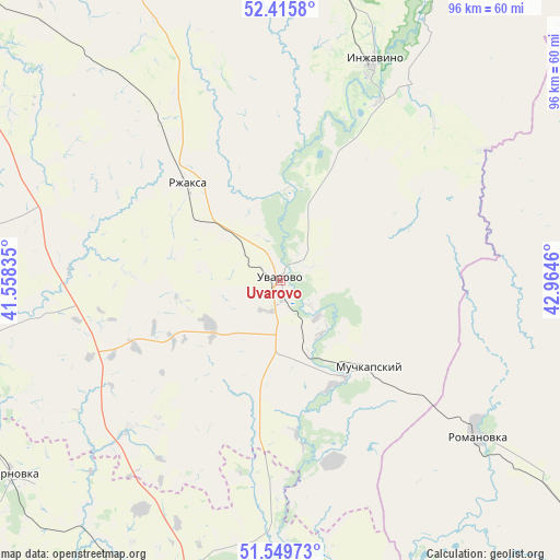
Uvarovo GPS coordinates[2]
51° 59' 5.496" North, 42° 15' 41.292" East
| Map corner | latitude | longitude |
|---|---|---|
| Upper-left | 52.4158°, | 41.55835° |
| Center: | 51.98486°, | 42.26147° |
| Lower-right: | 51.54973°, | 42.9646° |
| Map W x H: | 96.3×96.3 km | = 59.8×59.8mi |
| max Lat: | 73.50819° ⇑69.3% North |
| Uvarovo: | 51.98486° |
| min Lat: | ⇓30.7% South 41.28413° |
| min Long | Uvarovo | max Long |
| -179.12198° | 42.26147° | 179.35046° |
| W 41.2%⇐ | ⇒58.8% E |
Elevation
Elevation of Uvarovo is 147 m = 482 ft, and this is 55.6 m = 182 ft below average elevation for this country.
| Max E: |
2518 m = 8261 ft | 48.9% |
| Avg. | 202.6 m = 665 ft | |
| Uvarovo | 147 m = 482 ft | |
Min E: |
-28 m = -92 ft | 51.1% |
See also: Russia elevation on elevation.city.
Geographical zone
Uvarovo is located in North temperate zone (between Tropic of Cancer and the Arctic Circle). Distance of this North polar circle is 1621 km =1007.2 mi to North.| Distance of | km | miles | from Uvarovo |
|---|---|---|---|
| North Pole | 4226.9 | 2626.5 | to North |
| Arctic Circle | 1621 | 1007.2 | to North |
| Tropic Cancer | 3174.3 | 1972.4 | to South |
| Equator | 5780.2 | 3591.6 | to South |


Nearby cities:
15 places around Uvarovo: (largest is in red/bold)
• Balashov
78.8 km =49 mi,  127°
127°
• Bol’shoy Karay
51.5 km =32 mi,  145°
145°
• Borisoglebsk
69.8 km =43.4 mi,  190°
190°
• Gribanovskiy
61.8 km =38.4 mi,  198°
198°
• Inzhavino
40.3 km =25 mi,  23°
23°
• Muchkapskiy
20.7 km =12.9 mi,  135°
135°
• Pinerovka
72.8 km =45.2 mi, 130°
• Repnoye
77.1 km =47.9 mi,  124°
124°
• Romanovka
43 km =26.7 mi, 128°
• Rzhaksa
23.1 km =14.4 mi,  315°
315°
• Satinka
59 km =36.7 mi, 317°
• Ternovka
54.8 km =34.1 mi,  231°
231°
• Turki
69.3 km =43.1 mi,  89°
89°
• Zherdevka
57 km =35.4 mi,  254°
254°
• Znamenka
74.2 km =46.1 mi,  310°
310°
Sources, notices
• [Note1] Compared only with cities in Russia existing in our database
• [Src1] Map data: © OpenStreetMap contributors (CC-BY-SA)
• [Src2] Other city data from geonames.org with taken over terms of usage.
• [Src3] Geographical zone / Annual Mean Temperature by Robert A. Rohde @ Wikipedia
