Muchkapskiy geodata
Muchkapskiy (Tambov) is a populated place; located in Russia in Europe/Moscow (GMT+3) time zone. With population of 7,814 people, there are 1851 cities with bigger population in this country. Compared to other cities in Russia, 70% of cities are located further ↑North; 58.4% of cities are located further →East and 67.2% of cities have higher elevation than Muchkapskiy. Note1


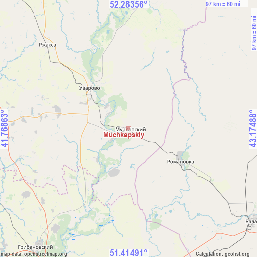
Muchkapskiy GPS coordinates[2]
51° 51' 4.788" North, 42° 28' 18.3" East
| Map corner | latitude | longitude |
|---|---|---|
| Upper-left | 52.28356°, | 41.76863° |
| Center: | 51.85133°, | 42.47175° |
| Lower-right: | 51.41491°, | 43.17488° |
| Map W x H: | 96.6×96.6 km | = 60×60mi |
| max Lat: | 73.50819° ⇑70% North |
| Muchkapskiy: | 51.85133° |
| min Lat: | ⇓30% South 41.28413° |
| min Long | Muchkapskiy | max Long |
| -179.12198° | 42.47175° | 179.35046° |
| W 41.6%⇐ | ⇒58.4% E |
Elevation
Elevation of Muchkapskiy is 109 m = 358 ft, and this is 93.6 m = 307 ft below average elevation for this country.
| Max E: |
2518 m = 8261 ft | 67.2% |
| Avg. | 202.6 m = 665 ft | |
| Muchkapskiy | 109 m = 358 ft | |
Min E: |
-28 m = -92 ft | 32.8% |
See also: Russia elevation on elevation.city.
Geographical zone
Muchkapskiy is located in North temperate zone (between Tropic of Cancer and the Arctic Circle). Distance of this North polar circle is 1635.8 km =1016.4 mi to North.| Distance of | km | miles | from Muchkapskiy |
|---|---|---|---|
| North Pole | 4241.7 | 2635.7 | to North |
| Arctic Circle | 1635.8 | 1016.4 | to North |
| Tropic Cancer | 3159.4 | 1963.2 | to South |
| Equator | 5765.3 | 3582.4 | to South |


Nearby cities:
15 places around Muchkapskiy: (largest is in red/bold)
• Arkadak
71 km =44.1 mi,  82°
82°
• Balashov
58.4 km =36.3 mi,  124°
124°
• Bol’shoy Karay
31.2 km =19.4 mi,  151°
151°
• Borisoglebsk
60.1 km =37.3 mi,  206°
206°
• Gribanovskiy
55.5 km =34.5 mi,  217°
217°
• Inzhavino
52 km =32.3 mi,  1°
1°
• Kamenka
62.3 km =38.7 mi,  160°
160°
• Pinerovka
52.2 km =32.4 mi,  128°
128°
• Repnoye
57 km =35.4 mi, 120°
• Romanovka
22.7 km =14.1 mi, 121°
• Rzhaksa
43.8 km =27.2 mi,  315°
315°
• Ternovka
60.6 km =37.7 mi,  251°
251°
• Turki
57 km =35.4 mi,  74°
74°
• Uvarovo
20.7 km =12.9 mi, 315°
• Zherdevka
69.5 km =43.2 mi,  269°
269°
Sources, notices
• [Note1] Compared only with cities in Russia existing in our database
• [Src1] Map data: © OpenStreetMap contributors (CC-BY-SA)
• [Src2] Other city data from geonames.org with taken over terms of usage.
• [Src3] Geographical zone / Annual Mean Temperature by Robert A. Rohde @ Wikipedia
