Kalino geodata
Kalino (Perm) is a populated place; located in Russia in Asia/Yekaterinburg (GMT+5) time zone. With population of 2,473 people, there are 3969 cities with bigger population in this country. Compared to other cities in Russia, 83.6% of cities are located further ↓South; 69.1% of cities are located further ←West and 54.2% of cities have higher elevation than Kalino. Note1


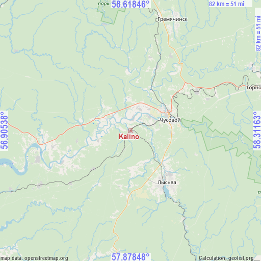
Kalino GPS coordinates[2]
58° 15' 1.44" North, 57° 36' 30.6" East
| Map corner | latitude | longitude |
|---|---|---|
| Upper-left | 58.61846°, | 56.90538° |
| Center: | 58.2504°, | 57.6085° |
| Lower-right: | 57.87848°, | 58.31163° |
| Map W x H: | 82.3×82.3 km | = 51.1×51.1mi |
| max Lat: | 73.50819° ⇑16.4% North |
| Kalino: | 58.2504° |
| min Lat: | ⇓83.6% South 41.28413° |
| min Long | Kalino | max Long |
| -179.12198° | 57.6085° | 179.35046° |
| W 69.1%⇐ | ⇒30.9% E |
Elevation
Elevation of Kalino is 136 m = 446 ft, and this is 66.6 m = 219 ft below average elevation for this country.
| Max E: |
2518 m = 8261 ft | 54.2% |
| Avg. | 202.6 m = 665 ft | |
| Kalino | 136 m = 446 ft | |
Min E: |
-28 m = -92 ft | 45.8% |
See also: Russia elevation on elevation.city.
Geographical zone
Kalino is located in North temperate zone (between Tropic of Cancer and the Arctic Circle). Distance of this North polar circle is 924.3 km =574.3 mi to North.| Distance of | km | miles | from Kalino |
|---|---|---|---|
| North Pole | 3530.2 | 2193.6 | to North |
| Arctic Circle | 924.3 | 574.3 | to North |
| Tropic Cancer | 3870.9 | 2405.3 | to South |
| Equator | 6476.8 | 4024.5 | to South |


Nearby cities:
15 places around Kalino: (largest is in red/bold)
• Chusovoy
13.2 km =8.2 mi,  64°
64°
• Gornozavodsk
43.9 km =27.3 mi,  71°
71°
• Gremyachinsk
37.2 km =23.1 mi,  22°
22°
• Gubakha
65.5 km =40.7 mi,  357°
357°
• Komarikhinskiy
33.5 km =20.8 mi,  239°
239°
• Lyamino
7.8 km =4.8 mi, 61°
• Lys’va
19.5 km =12.1 mi,  143°
143°
• Nagornskiy
57.8 km =35.9 mi, 356°
• Novyye Lyady
62.5 km =38.8 mi,  249°
249°
• Pashiya
42.9 km =26.7 mi, 61°
• Shirokovskiy
66.5 km =41.3 mi,  8°
8°
• Shumikhinskiy
55.2 km =34.3 mi, 5°
• Sylva
54.8 km =34.1 mi, 243°
• Verkhnechusovskiye Gorodki
30.7 km =19.1 mi, 252°
• Yubileynyy
59.7 km =37.1 mi, 9°
Sources, notices
• [Note1] Compared only with cities in Russia existing in our database
• [Src1] Map data: © OpenStreetMap contributors (CC-BY-SA)
• [Src2] Other city data from geonames.org with taken over terms of usage.
• [Src3] Geographical zone / Annual Mean Temperature by Robert A. Rohde @ Wikipedia
