Kalininskaya geodata
Kalininskaya (Krasnodarskiy) is a seat of a second-order administrative division; located in Russia in Europe/Moscow (GMT+3) time zone. With population of 13,363 people, there are 1178 cities with bigger population in this country. Compared to other cities in Russia, 85.2% of cities are located further ↑North; 73.7% of cities are located further →East and 95.9% of cities have higher elevation than Kalininskaya. Note1


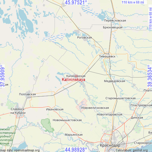
Kalininskaya GPS coordinates[2]
45° 29' 3.84" North, 38° 39' 43.956" East
| Map corner | latitude | longitude |
|---|---|---|
| Upper-left | 45.97521°, | 37.95909° |
| Center: | 45.4844°, | 38.66221° |
| Lower-right: | 44.98928°, | 39.36534° |
| Map W x H: | 109.6×109.6 km | = 68.1×68.1mi |
| max Lat: | 73.50819° ⇑85.2% North |
| Kalininskaya: | 45.4844° |
| min Lat: | ⇓14.8% South 41.28413° |
| min Long | Kalininskaya | max Long |
| -179.12198° | 38.66221° | 179.35046° |
| W 26.3%⇐ | ⇒73.7% E |
Elevation
Elevation of Kalininskaya is 10 m = 33 ft, and this is 192.6 m = 632 ft below average elevation for this country.
| Max E: |
2518 m = 8261 ft | 95.9% |
| Avg. | 202.6 m = 665 ft | |
| Kalininskaya | 10 m = 33 ft | |
Min E: |
-28 m = -92 ft | 4.1% |
See also: Russia elevation on elevation.city.
Geographical zone
Kalininskaya is located in North temperate zone (between Tropic of Cancer and the Arctic Circle). Distance of this North polar circle is 2343.8 km =1456.4 mi to North.| Distance of | km | miles | from Kalininskaya |
|---|---|---|---|
| North Pole | 4949.7 | 3075.6 | to North |
| Arctic Circle | 2343.8 | 1456.4 | to North |
| Tropic Cancer | 2451.5 | 1523.3 | to South |
| Equator | 5057.4 | 3142.5 | to South |


Nearby cities:
15 places around Kalininskaya: (largest is in red/bold)
• Dneprovskaya
19.2 km =11.9 mi,  36°
36°
• Grivenskaya
42 km =26.1 mi,  295°
295°
• Krasnoarmeyskaya
37.5 km =23.3 mi,  249°
249°
• Medvedovskaya
28.5 km =17.7 mi,  97°
97°
• Novodzhereliyevskaya
32.2 km =20 mi,  1°
1°
• Novokorsunskaya
41.5 km =25.8 mi,  65°
65°
• Novomyshastovskaya
32.3 km =20.1 mi,  191°
191°
• Novotitarovskaya
37 km =23 mi,  137°
137°
• Novovelichkovskaya
27 km =16.8 mi,  148°
148°
• Rogovskaya
28.1 km =17.5 mi,  12°
12°
• Starodzhereliyevskaya
28.5 km =17.7 mi,  268°
268°
• Staromyshastovskaya
35.9 km =22.3 mi,  115°
115°
• Staronizhestebliyevskaya
20.5 km =12.7 mi,  236°
236°
• Starovelichkovskaya
8.3 km =5.2 mi, 138°
• Timashëvsk
26.5 km =16.5 mi,  56°
56°
Sources, notices
• [Note1] Compared only with cities in Russia existing in our database
• [Src1] Map data: © OpenStreetMap contributors (CC-BY-SA)
• [Src2] Other city data from geonames.org with taken over terms of usage.
• [Src3] Geographical zone / Annual Mean Temperature by Robert A. Rohde @ Wikipedia
