Staromyshastovskaya geodata
Staromyshastovskaya (Krasnodarskiy) is a populated place; located in Russia in Europe/Moscow (GMT+3) time zone. With population of 10,625 people, there are 1422 cities with bigger population in this country. Compared to other cities in Russia, 85.9% of cities are located further ↑North; 71.8% of cities are located further →East and 91.9% of cities have higher elevation than Staromyshastovskaya. Note1


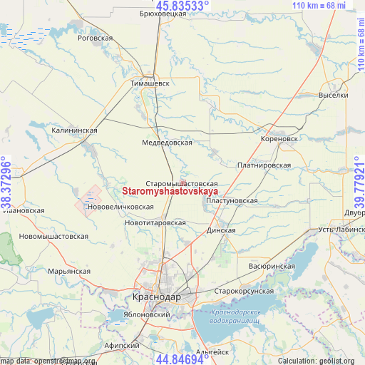
Staromyshastovskaya GPS coordinates[2]
45° 20' 35.844" North, 39° 4' 33.888" East
| Map corner | latitude | longitude |
|---|---|---|
| Upper-left | 45.83533°, | 38.37296° |
| Center: | 45.34329°, | 39.07608° |
| Lower-right: | 44.84694°, | 39.77921° |
| Map W x H: | 109.9×109.9 km | = 68.3×68.3mi |
| max Lat: | 73.50819° ⇑85.9% North |
| Staromyshastovskaya: | 45.34329° |
| min Lat: | ⇓14.1% South 41.28413° |
| min Long | Staromyshastovs | max Long |
| -179.12198° | 39.07608° | 179.35046° |
| W 28.2%⇐ | ⇒71.8% E |
Elevation
Elevation of Staromyshastovskaya is 22 m = 72 ft, and this is 180.6 m = 593 ft below average elevation for this country.
| Max E: |
2518 m = 8261 ft | 91.9% |
| Avg. | 202.6 m = 665 ft | |
| Staromyshastovskaya | 22 m = 72 ft | |
Min E: |
-28 m = -92 ft | 8.1% |
See also: Russia elevation on elevation.city.
Geographical zone
Staromyshastovskaya is located in North temperate zone (between Tropic of Cancer and the Arctic Circle). Distance of this North polar circle is 2359.5 km =1466.1 mi to North.| Distance of | km | miles | from Staromyshastovskaya |
|---|---|---|---|
| North Pole | 4965.4 | 3085.4 | to North |
| Arctic Circle | 2359.5 | 1466.1 | to North |
| Tropic Cancer | 2435.8 | 1513.5 | to South |
| Equator | 5041.7 | 3132.8 | to South |


Nearby cities:
15 places around Staromyshastovskaya: (largest is in red/bold)
• Agronom
24.4 km =15.2 mi,  157°
157°
• Dinskaya
18.5 km =11.5 mi,  140°
140°
• Kalininskaya
35.9 km =22.3 mi,  295°
295°
• Korenovsk
32.5 km =20.2 mi,  64°
64°
• Krasnodar
34.1 km =21.2 mi,  193°
193°
• Medvedovskaya
12.7 km =7.9 mi,  341°
341°
• Novokorsunskaya
33.5 km =20.8 mi,  9°
9°
• Novotitarovskaya
13.9 km =8.6 mi,  212°
212°
• Novovelichkovskaya
19.8 km =12.3 mi,  247°
247°
• Pashkovskiy
35.6 km =22.1 mi,  176°
176°
• Plastunovskaya
15.7 km =9.8 mi,  110°
110°
• Platnirovskaya
24.8 km =15.4 mi,  76°
76°
• Starokorsunskaya
36.9 km =22.9 mi,  149°
149°
• Starovelichkovskaya
28.5 km =17.7 mi,  289°
289°
• Timashëvsk
32.1 km =19.9 mi, 341°
Sources, notices
• [Note1] Compared only with cities in Russia existing in our database
• [Src1] Map data: © OpenStreetMap contributors (CC-BY-SA)
• [Src2] Other city data from geonames.org with taken over terms of usage.
• [Src3] Geographical zone / Annual Mean Temperature by Robert A. Rohde @ Wikipedia
