Fryanovo geodata
Fryanovo (Moscow Oblast) is a populated place; located in Russia in Europe/Moscow (GMT+3) time zone. With population of 11,088 people, there are 1363 cities with bigger population in this country. Compared to other cities in Russia, 68.4% of cities are located further ↓South; 74.6% of cities are located further →East and 58.2% of cities have lower elevation than Fryanovo. Note1


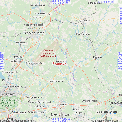
Fryanovo GPS coordinates[2]
56° 7' 59.988" North, 38° 27' 0" East
| Map corner | latitude | longitude |
|---|---|---|
| Upper-left | 56.52316°, | 37.74688° |
| Center: | 56.13333°, | 38.45° |
| Lower-right: | 55.73951°, | 39.15313° |
| Map W x H: | 87.1×87.1 km | = 54.1×54.1mi |
| max Lat: | 73.50819° ⇑31.6% North |
| Fryanovo: | 56.13333° |
| min Lat: | ⇓68.4% South 41.28413° |
| min Long | Fryanovo | max Long |
| -179.12198° | 38.45° | 179.35046° |
| W 25.4%⇐ | ⇒74.6% E |
Elevation
Elevation of Fryanovo is 164 m = 538 ft, and this is 38.6 m = 127 ft below average elevation for this country.
| Max E: |
2518 m = 8261 ft | 41.8% |
| Avg. | 202.6 m = 665 ft | |
| Fryanovo | 164 m = 538 ft | |
Min E: |
-28 m = -92 ft | 58.2% |
See also: Russia elevation on elevation.city.
Geographical zone
Fryanovo is located in North temperate zone (between Tropic of Cancer and the Arctic Circle). Distance of this North polar circle is 1159.7 km =720.6 mi to North.| Distance of | km | miles | from Fryanovo |
|---|---|---|---|
| North Pole | 3765.6 | 2339.8 | to North |
| Arctic Circle | 1159.7 | 720.6 | to North |
| Tropic Cancer | 3635.5 | 2259 | to South |
| Equator | 6241.4 | 3878.2 | to South |


Nearby cities:
15 places around Fryanovo: (largest is in red/bold)
• Arsaki
27.9 km =17.3 mi,  4°
4°
• Bogoslovo
27.1 km =16.8 mi,  241°
241°
• Chernogolovka
15.7 km =9.8 mi,  199°
199°
• Karabanovo
25.6 km =15.9 mi,  37°
37°
• Kirzhach
25.2 km =15.7 mi,  85°
85°
• Krasnoarmeysk
20 km =12.4 mi,  259°
259°
• Krasnyy Oktyabr’
26.9 km =16.7 mi, 93°
• Noginsk
29.7 km =18.5 mi,  180°
180°
• Noginsk-9
8 km =5 mi,  157°
157°
• Semkhoz
29 km =18 mi,  305°
305°
• Sergiyev Posad
27 km =16.8 mi, 313°
• Stromyn’
10.2 km =6.3 mi,  168°
168°
• Strunino
27.9 km =17.3 mi,  17°
17°
• Yamkino
23.8 km =14.8 mi,  186°
186°
• Zhukovka
29.4 km =18.3 mi,  251°
251°
Sources, notices
• [Note1] Compared only with cities in Russia existing in our database
• [Src1] Map data: © OpenStreetMap contributors (CC-BY-SA)
• [Src2] Other city data from geonames.org with taken over terms of usage.
• [Src3] Geographical zone / Annual Mean Temperature by Robert A. Rohde @ Wikipedia
