Donskoy geodata
Donskoy (Rostov) is a populated place; located in Russia in Europe/Moscow (GMT+3) time zone. With population of 13,627 people, there are 1162 cities with bigger population in this country. Compared to other cities in Russia, 81.4% of cities are located further ↑North; 66.2% of cities are located further →East and 95.2% of cities have higher elevation than Donskoy. Note1


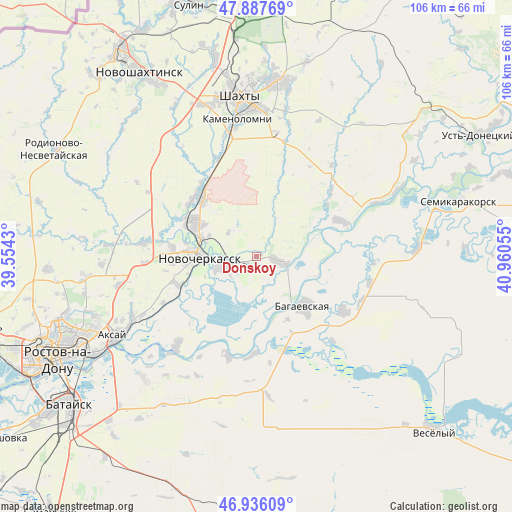
Donskoy GPS coordinates[2]
47° 24' 50.544" North, 40° 15' 26.712" East
| Map corner | latitude | longitude |
|---|---|---|
| Upper-left | 47.88769°, | 39.5543° |
| Center: | 47.41404°, | 40.25742° |
| Lower-right: | 46.93609°, | 40.96055° |
| Map W x H: | 105.8×105.8 km | = 65.7×65.7mi |
| max Lat: | 73.50819° ⇑81.4% North |
| Donskoy: | 47.41404° |
| min Lat: | ⇓18.6% South 41.28413° |
| min Long | Donskoy | max Long |
| -179.12198° | 40.25742° | 179.35046° |
| W 33.8%⇐ | ⇒66.2% E |
Elevation
Elevation of Donskoy is 12 m = 39 ft, and this is 190.6 m = 625 ft below average elevation for this country.
| Max E: |
2518 m = 8261 ft | 95.2% |
| Avg. | 202.6 m = 665 ft | |
| Donskoy | 12 m = 39 ft | |
Min E: |
-28 m = -92 ft | 4.8% |
See also: Russia elevation on elevation.city.
Geographical zone
Donskoy is located in North temperate zone (between Tropic of Cancer and the Arctic Circle). Distance of this North polar circle is 2129.2 km =1323 mi to North.| Distance of | km | miles | from Donskoy |
|---|---|---|---|
| North Pole | 4735.1 | 2942.3 | to North |
| Arctic Circle | 2129.2 | 1323 | to North |
| Tropic Cancer | 2666 | 1656.6 | to South |
| Equator | 5271.9 | 3275.8 | to South |


Nearby cities:
15 places around Donskoy: (largest is in red/bold)
• Aksay
34.1 km =21.2 mi,  239°
239°
• Bagayevskaya
14 km =8.7 mi,  135°
135°
• Grushevskaya
23.2 km =14.4 mi,  277°
277°
• Imeni Chkalova
41.1 km =25.5 mi,  248°
248°
• Kamenolomni
28.6 km =17.8 mi,  352°
352°
• Krasyukovskaya
19 km =11.8 mi,  323°
323°
• Krivyanskaya
7.1 km =4.4 mi, 254°
• Mayskiy
33.4 km =20.8 mi,  339°
339°
• Melikhovskaya
18.8 km =11.7 mi,  66°
66°
• Novocherkassk
12.5 km =7.8 mi,  273°
273°
• Novosvetlovsky
26.2 km =16.3 mi, 347°
• Ol’ginskaya
34.2 km =21.3 mi,  222°
222°
• Shakhty
33 km =20.5 mi, 354°
• Starocherkasskaya
25.2 km =15.7 mi, 220°
• Verkhnetemernitzkiy
40.9 km =25.4 mi, 253°
Sources, notices
• [Note1] Compared only with cities in Russia existing in our database
• [Src1] Map data: © OpenStreetMap contributors (CC-BY-SA)
• [Src2] Other city data from geonames.org with taken over terms of usage.
• [Src3] Geographical zone / Annual Mean Temperature by Robert A. Rohde @ Wikipedia
