Aksay geodata
Aksay (Rostov) is a seat of a second-order administrative division; located in Russia in Europe/Moscow (GMT+3) time zone. With population of 38,871 people, there are 539 cities with bigger population in this country. Compared to other cities in Russia, 81.8% of cities are located further ↑North; 68.2% of cities are located further →East and 79.6% of cities have higher elevation than Aksay. Note1


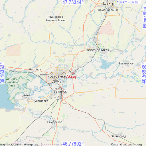
Aksay GPS coordinates[2]
47° 15' 30.168" North, 39° 52' 0.3" East
| Map corner | latitude | longitude |
|---|---|---|
| Upper-left | 47.73344°, | 39.16363° |
| Center: | 47.25838°, | 39.86675° |
| Lower-right: | 46.77902°, | 40.56988° |
| Map W x H: | 106.1×106.1 km | = 65.9×65.9mi |
| max Lat: | 73.50819° ⇑81.8% North |
| Aksay: | 47.25838° |
| min Lat: | ⇓18.2% South 41.28413° |
| min Long | Aksay | max Long |
| -179.12198° | 39.86675° | 179.35046° |
| W 31.8%⇐ | ⇒68.2% E |
Elevation
Elevation of Aksay is 72 m = 236 ft, and this is 130.6 m = 428 ft below average elevation for this country.
| Max E: |
2518 m = 8261 ft | 79.6% |
| Avg. | 202.6 m = 665 ft | |
| Aksay | 72 m = 236 ft | |
Min E: |
-28 m = -92 ft | 20.4% |
See also: Russia elevation on elevation.city.
Geographical zone
Aksay is located in North temperate zone (between Tropic of Cancer and the Arctic Circle). Distance of this North polar circle is 2146.5 km =1333.8 mi to North.| Distance of | km | miles | from Aksay |
|---|---|---|---|
| North Pole | 4752.4 | 2953 | to North |
| Arctic Circle | 2146.5 | 1333.8 | to North |
| Tropic Cancer | 2648.7 | 1645.8 | to South |
| Equator | 5254.6 | 3265.1 | to South |


Nearby cities:
15 places around Aksay: (largest is in red/bold)
• Bataysk
15.8 km =9.8 mi,  213°
213°
• Chaltyr
29.2 km =18.1 mi,  275°
275°
• Donskoy
34.1 km =21.2 mi,  59°
59°
• Grushevskaya
21.2 km =13.2 mi,  17°
17°
• Imeni Chkalova
9.3 km =5.8 mi,  286°
286°
• Kalinin
26.9 km =16.7 mi,  267°
267°
• Krivyanskaya
27.4 km =17 mi, 55°
• Krym
26.8 km =16.7 mi, 279°
• Kuleshovka
30.8 km =19.1 mi,  229°
229°
• Novocherkassk
24.8 km =15.4 mi,  43°
43°
• Ol’ginskaya
10 km =6.2 mi,  141°
141°
• Rostov-na-Donu
11.2 km =7 mi,  254°
254°
• Severnyy
12.1 km =7.5 mi, 286°
• Starocherkasskaya
13.4 km =8.3 mi,  98°
98°
• Verkhnetemernitzkiy
11.4 km =7.1 mi,  300°
300°
Sources, notices
• [Note1] Compared only with cities in Russia existing in our database
• [Src1] Map data: © OpenStreetMap contributors (CC-BY-SA)
• [Src2] Other city data from geonames.org with taken over terms of usage.
• [Src3] Geographical zone / Annual Mean Temperature by Robert A. Rohde @ Wikipedia
