Starocherkasskaya geodata
Starocherkasskaya (Rostov) is a populated place; located in Russia in Europe/Moscow (GMT+3) time zone. With population of 5,060 people, there are 2633 cities with bigger population in this country. Compared to other cities in Russia, 81.9% of cities are located further ↑North; 67.4% of cities are located further →East and 98.5% of cities have higher elevation than Starocherkasskaya. Note1


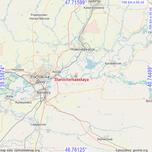
Starocherkasskaya GPS coordinates[2]
47° 14' 26.772" North, 40° 2' 30.696" East
| Map corner | latitude | longitude |
|---|---|---|
| Upper-left | 47.71599°, | 39.33874° |
| Center: | 47.24077°, | 40.04186° |
| Lower-right: | 46.76125°, | 40.74499° |
| Map W x H: | 106.2×106.2 km | = 66×66mi |
| max Lat: | 73.50819° ⇑81.9% North |
| Starocherkasskaya: | 47.24077° |
| min Lat: | ⇓18.1% South 41.28413° |
| min Long | Starocherkasska | max Long |
| -179.12198° | 40.04186° | 179.35046° |
| W 32.6%⇐ | ⇒67.4% E |
Elevation
Elevation of Starocherkasskaya is 2 m = 7 ft, and this is 200.6 m = 658 ft below average elevation for this country.
| Max E: |
2518 m = 8261 ft | 98.5% |
| Avg. | 202.6 m = 665 ft | |
| Starocherkasskaya | 2 m = 7 ft | |
Min E: |
-28 m = -92 ft | 1.5% |
See also: Russia elevation on elevation.city.
Geographical zone
Starocherkasskaya is located in North temperate zone (between Tropic of Cancer and the Arctic Circle). Distance of this North polar circle is 2148.5 km =1335 mi to North.| Distance of | km | miles | from Starocherkasskaya |
|---|---|---|---|
| North Pole | 4754.4 | 2954.2 | to North |
| Arctic Circle | 2148.5 | 1335 | to North |
| Tropic Cancer | 2646.8 | 1644.6 | to South |
| Equator | 5252.7 | 3263.9 | to South |


Nearby cities:
15 places around Starocherkasskaya: (largest is in red/bold)
• Aksay
13.4 km =8.3 mi,  278°
278°
• Bagayevskaya
27.7 km =17.2 mi,  70°
70°
• Bataysk
24.6 km =15.3 mi,  242°
242°
• Donskoy
25.2 km =15.7 mi,  40°
40°
• Grushevskaya
23.2 km =14.4 mi,  342°
342°
• Imeni Chkalova
22.6 km =14 mi, 281°
• Kalinin
40.1 km =24.9 mi,  270°
270°
• Kirovskaya
29.6 km =18.4 mi,  180°
180°
• Krasyukovskaya
35 km =21.7 mi,  8°
8°
• Krivyanskaya
19.7 km =12.2 mi,  28°
28°
• Novocherkassk
20.4 km =12.7 mi, 10°
• Ol’ginskaya
9.1 km =5.7 mi,  229°
229°
• Rostov-na-Donu
24.1 km =15 mi, 267°
• Severnyy
25.4 km =15.8 mi, 282°
• Verkhnetemernitzkiy
24.3 km =15.1 mi,  288°
288°
Sources, notices
• [Note1] Compared only with cities in Russia existing in our database
• [Src1] Map data: © OpenStreetMap contributors (CC-BY-SA)
• [Src2] Other city data from geonames.org with taken over terms of usage.
• [Src3] Geographical zone / Annual Mean Temperature by Robert A. Rohde @ Wikipedia
