Kamenolomni geodata
Kamenolomni (Rostov) is a seat of a second-order administrative division; located in Russia in Europe/Moscow (GMT+3) time zone. With population of 12,262 people, there are 1254 cities with bigger population in this country. Compared to other cities in Russia, 80.9% of cities are located further ↑North; 66.5% of cities are located further →East and 82.2% of cities have higher elevation than Kamenolomni. Note1


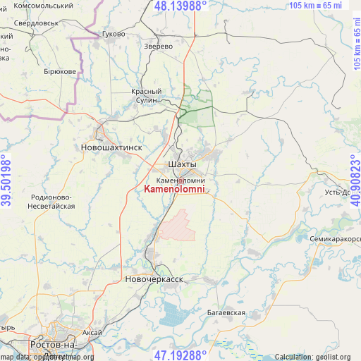
Kamenolomni GPS coordinates[2]
47° 40' 6.708" North, 40° 12' 18.36" East
| Map corner | latitude | longitude |
|---|---|---|
| Upper-left | 48.13988°, | 39.50198° |
| Center: | 47.66853°, | 40.2051° |
| Lower-right: | 47.19288°, | 40.90823° |
| Map W x H: | 105.3×105.3 km | = 65.4×65.4mi |
| max Lat: | 73.50819° ⇑80.9% North |
| Kamenolomni: | 47.66853° |
| min Lat: | ⇓19.1% South 41.28413° |
| min Long | Kamenolomni | max Long |
| -179.12198° | 40.2051° | 179.35046° |
| W 33.5%⇐ | ⇒66.5% E |
Elevation
Elevation of Kamenolomni is 62 m = 203 ft, and this is 140.6 m = 461 ft below average elevation for this country.
| Max E: |
2518 m = 8261 ft | 82.2% |
| Avg. | 202.6 m = 665 ft | |
| Kamenolomni | 62 m = 203 ft | |
Min E: |
-28 m = -92 ft | 17.8% |
See also: Russia elevation on elevation.city.
Geographical zone
Kamenolomni is located in North temperate zone (between Tropic of Cancer and the Arctic Circle). Distance of this North polar circle is 2100.9 km =1305.4 mi to North.| Distance of | km | miles | from Kamenolomni |
|---|---|---|---|
| North Pole | 4706.8 | 2924.7 | to North |
| Arctic Circle | 2100.9 | 1305.4 | to North |
| Tropic Cancer | 2694.3 | 1674.2 | to South |
| Equator | 5300.2 | 3293.4 | to South |


Nearby cities:
15 places around Kamenolomni: (largest is in red/bold)
• Ayutinskiy
13.4 km =8.3 mi,  341°
341°
• Donskoy
28.6 km =17.8 mi,  172°
172°
• Gornyy
16.4 km =10.2 mi,  359°
359°
• Krasnyy Sulin
26.8 km =16.7 mi, 337°
• Krasyukovskaya
14.8 km =9.2 mi,  209°
209°
• Krivyanskaya
30.3 km =18.8 mi,  185°
185°
• Mayskiy
8.3 km =5.2 mi,  291°
291°
• Melikhovskaya
29.7 km =18.5 mi,  134°
134°
• Novocherkassk
28.8 km =17.9 mi,  197°
197°
• Novoshakhtinsk
22.8 km =14.2 mi,  296°
296°
• Novosvetlovsky
3.2 km =2 mi, 211°
• Sambek
29.2 km =18.1 mi, 286°
• Shakhty
4.6 km =2.9 mi,  8°
8°
• Sokolovo-Kundryuchenskiy
26.8 km =16.7 mi,  313°
313°
• Talovyy
17 km =10.6 mi, 335°
Sources, notices
• [Note1] Compared only with cities in Russia existing in our database
• [Src1] Map data: © OpenStreetMap contributors (CC-BY-SA)
• [Src2] Other city data from geonames.org with taken over terms of usage.
• [Src3] Geographical zone / Annual Mean Temperature by Robert A. Rohde @ Wikipedia
