Chaplygin geodata
Chaplygin (Lipetsk Oblast) is a populated place; located in Russia in Europe/Moscow (GMT+3) time zone. With population of 13,488 people, there are 1170 cities with bigger population in this country. Compared to other cities in Russia, 61% of cities are located further ↑North; 67.6% of cities are located further →East and 51.5% of cities have lower elevation than Chaplygin. Note1


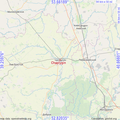
Chaplygin GPS coordinates[2]
53° 14' 35.484" North, 39° 57' 46.368" East
| Map corner | latitude | longitude |
|---|---|---|
| Upper-left | 53.66189°, | 39.25976° |
| Center: | 53.24319°, | 39.96288° |
| Lower-right: | 52.82035°, | 40.66601° |
| Map W x H: | 93.6×93.6 km | = 58.2×58.2mi |
| max Lat: | 73.50819° ⇑61% North |
| Chaplygin: | 53.24319° |
| min Lat: | ⇓39% South 41.28413° |
| min Long | Chaplygin | max Long |
| -179.12198° | 39.96288° | 179.35046° |
| W 32.4%⇐ | ⇒67.6% E |
Elevation
Elevation of Chaplygin is 148 m = 486 ft, and this is 54.6 m = 179 ft below average elevation for this country.
| Max E: |
2518 m = 8261 ft | 48.5% |
| Avg. | 202.6 m = 665 ft | |
| Chaplygin | 148 m = 486 ft | |
Min E: |
-28 m = -92 ft | 51.5% |
See also: Russia elevation on elevation.city.
Geographical zone
Chaplygin is located in North temperate zone (between Tropic of Cancer and the Arctic Circle). Distance of this North polar circle is 1481.1 km =920.3 mi to North.| Distance of | km | miles | from Chaplygin |
|---|---|---|---|
| North Pole | 4087 | 2539.5 | to North |
| Arctic Circle | 1481.1 | 920.3 | to North |
| Tropic Cancer | 3314.2 | 2059.3 | to South |
| Equator | 5920.1 | 3678.6 | to South |


Nearby cities:
15 places around Chaplygin: (largest is in red/bold)
• Aleksandro-Nevskiy
30.5 km =19 mi,  32°
32°
• Bol’shoy Khomutets
51.5 km =32 mi,  186°
186°
• Dankov
53.7 km =33.4 mi,  270°
270°
• Dobroye
43 km =26.7 mi, 193°
• Kalikino
33.9 km =21.1 mi,  195°
195°
• Lebedyan’
58.7 km =36.5 mi,  244°
244°
• Lev Tolstoy
34.6 km =21.5 mi,  264°
264°
• Michurinsk
52.1 km =32.4 mi,  137°
137°
• Miloslavskoye
51.2 km =31.8 mi,  317°
317°
• Pervomayskiy
21.6 km =13.4 mi,  88°
88°
• Poplevinskiy
56.4 km =35 mi,  330°
330°
• Ryazhsk
52.1 km =32.4 mi,  10°
10°
• Staroyur’yevo
50.2 km =31.2 mi,  80°
80°
• Zarechnyy
59.4 km =36.9 mi,  335°
335°
• Zavoronezhskoye
56.4 km =35 mi, 135°
Sources, notices
• [Note1] Compared only with cities in Russia existing in our database
• [Src1] Map data: © OpenStreetMap contributors (CC-BY-SA)
• [Src2] Other city data from geonames.org with taken over terms of usage.
• [Src3] Geographical zone / Annual Mean Temperature by Robert A. Rohde @ Wikipedia
