Lermontovo geodata
Lermontovo (Penza) is a populated place; located in Russia in Europe/Moscow (GMT+3) time zone. With population of 1,649 people, there are 4315 cities with bigger population in this country. Compared to other cities in Russia, 62.8% of cities are located further ↑North; 54% of cities are located further →East and 75% of cities have lower elevation than Lermontovo. Note1


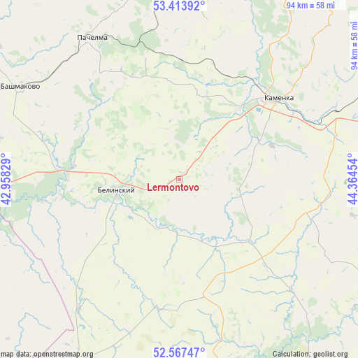
Lermontovo GPS coordinates[2]
52° 59' 33.972" North, 43° 39' 41.076" East
| Map corner | latitude | longitude |
|---|---|---|
| Upper-left | 53.41392°, | 42.95829° |
| Center: | 52.99277°, | 43.66141° |
| Lower-right: | 52.56747°, | 44.36454° |
| Map W x H: | 94.1×94.1 km | = 58.5×58.5mi |
| max Lat: | 73.50819° ⇑62.8% North |
| Lermontovo: | 52.99277° |
| min Lat: | ⇓37.2% South 41.28413° |
| min Long | Lermontovo | max Long |
| -179.12198° | 43.66141° | 179.35046° |
| W 46%⇐ | ⇒54% E |
Elevation
Elevation of Lermontovo is 217 m = 712 ft, and this is 14.4 m = 47 ft above average elevation for this country.
| Max E: |
2518 m = 8261 ft | 25% |
| Lermontovo | 217 m 712 ft | |
| Avg. | 202.6 m = 665 ft | |
Min E: |
-28 m = -92 ft | 75% |
See also: Russia elevation on elevation.city.
Geographical zone
Lermontovo is located in North temperate zone (between Tropic of Cancer and the Arctic Circle). Distance of this North polar circle is 1508.9 km =937.6 mi to North.| Distance of | km | miles | from Lermontovo |
|---|---|---|---|
| North Pole | 4114.8 | 2556.8 | to North |
| Arctic Circle | 1508.9 | 937.6 | to North |
| Tropic Cancer | 3286.3 | 2042 | to South |
| Equator | 5892.2 | 3661.2 | to South |


Nearby cities:
15 places around Lermontovo: (largest is in red/bold)
• Bashmakovo
48.5 km =30.1 mi,  300°
300°
• Bekovo
58.6 km =36.4 mi,  176°
176°
• Belinskiy
16.7 km =10.4 mi,  259°
259°
• Bogoslovka
79.8 km =49.6 mi,  72°
72°
• Gavrilovka Vtoraya
61.4 km =38.2 mi, 257°
• Kirsanov
73.4 km =45.6 mi,  239°
239°
• Kolyshley
67.2 km =41.8 mi,  118°
118°
• Mokshan
80.3 km =49.9 mi,  52°
52°
• Nizhniy Lomov
59.8 km =37.2 mi,  0°
0°
• Pachelma
34.8 km =21.6 mi,  323°
323°
• Poim
31.9 km =19.8 mi,  276°
276°
• Rakhmanovka
79.1 km =49.2 mi,  326°
326°
• Serdobsk
70.2 km =43.6 mi,  147°
147°
• Tamala
57.3 km =35.6 mi,  208°
208°
• Verkhniy Lomov
53.3 km =33.1 mi,  352°
352°
Sources, notices
• [Note1] Compared only with cities in Russia existing in our database
• [Src1] Map data: © OpenStreetMap contributors (CC-BY-SA)
• [Src2] Other city data from geonames.org with taken over terms of usage.
• [Src3] Geographical zone / Annual Mean Temperature by Robert A. Rohde @ Wikipedia
