Kirsanov geodata
Kirsanov (Tambov) is a populated place; located in Russia in Europe/Moscow (GMT+3) time zone. With population of 17,975 people, there are 956 cities with bigger population in this country. Compared to other cities in Russia, 65.2% of cities are located further ↑North; 57.7% of cities are located further →East and 53.1% of cities have lower elevation than Kirsanov. Note1


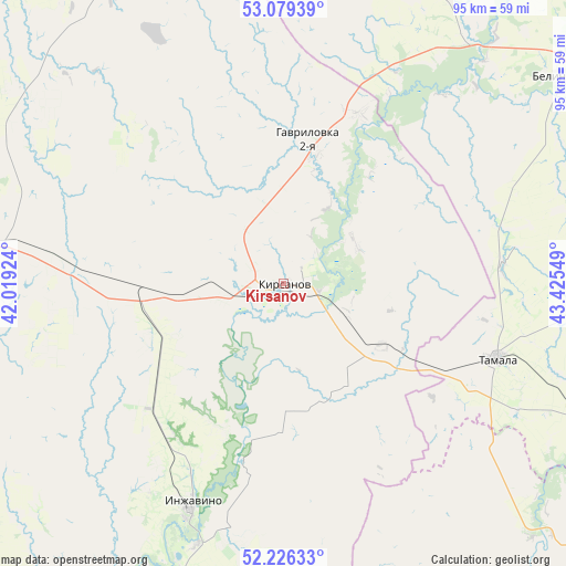
Kirsanov GPS coordinates[2]
52° 39' 17.784" North, 42° 43' 20.496" East
| Map corner | latitude | longitude |
|---|---|---|
| Upper-left | 53.07939°, | 42.01924° |
| Center: | 52.65494°, | 42.72236° |
| Lower-right: | 52.22633°, | 43.42549° |
| Map W x H: | 94.9×94.8 km | = 59×58.9mi |
| max Lat: | 73.50819° ⇑65.2% North |
| Kirsanov: | 52.65494° |
| min Lat: | ⇓34.8% South 41.28413° |
| min Long | Kirsanov | max Long |
| -179.12198° | 42.72236° | 179.35046° |
| W 42.3%⇐ | ⇒57.7% E |
Elevation
Elevation of Kirsanov is 152 m = 499 ft, and this is 50.6 m = 166 ft below average elevation for this country.
| Max E: |
2518 m = 8261 ft | 46.9% |
| Avg. | 202.6 m = 665 ft | |
| Kirsanov | 152 m = 499 ft | |
Min E: |
-28 m = -92 ft | 53.1% |
See also: Russia elevation on elevation.city.
Geographical zone
Kirsanov is located in North temperate zone (between Tropic of Cancer and the Arctic Circle). Distance of this North polar circle is 1546.5 km =961 mi to North.| Distance of | km | miles | from Kirsanov |
|---|---|---|---|
| North Pole | 4152.4 | 2580.2 | to North |
| Arctic Circle | 1546.5 | 961 | to North |
| Tropic Cancer | 3248.8 | 2018.7 | to South |
| Equator | 5854.7 | 3637.9 | to South |


Nearby cities:
15 places around Kirsanov: (largest is in red/bold)
• Bashmakovo
65.5 km =40.7 mi,  18°
18°
• Bekovo
70.1 km =43.6 mi,  107°
107°
• Belinskiy
58 km =36 mi,  53°
53°
• Gavrilovka Vtoraya
24.9 km =15.5 mi,  6°
6°
• Inzhavino
40.5 km =25.2 mi,  202°
202°
• Lermontovo
73.4 km =45.6 mi,  59°
59°
• Novaya Lyada
73.3 km =45.5 mi,  275°
275°
• Pachelma
77.9 km =48.4 mi,  32°
32°
• Pichayevo
73.4 km =45.6 mi,  331°
331°
• Platonovka
52.3 km =32.5 mi, 276°
• Poim
51.8 km =32.2 mi,  37°
37°
• Rasskazovo
56.5 km =35.1 mi,  270°
270°
• Rzhaksa
74.7 km =46.4 mi,  219°
219°
• Satinka
76.8 km =47.7 mi,  246°
246°
• Tamala
37.9 km =23.5 mi, 109°
Sources, notices
• [Note1] Compared only with cities in Russia existing in our database
• [Src1] Map data: © OpenStreetMap contributors (CC-BY-SA)
• [Src2] Other city data from geonames.org with taken over terms of usage.
• [Src3] Geographical zone / Annual Mean Temperature by Robert A. Rohde @ Wikipedia
