Babushkin geodata
Babushkin (Moscow) is a section of populated place; located in Russia in Europe/Moscow (GMT+3) time zone. With population of 86,000 people, there are 246 cities with bigger population in this country. Compared to other cities in Russia, 64.7% of cities are located further ↓South; 79.5% of cities are located further →East and 55.9% of cities have lower elevation than Babushkin. Note1


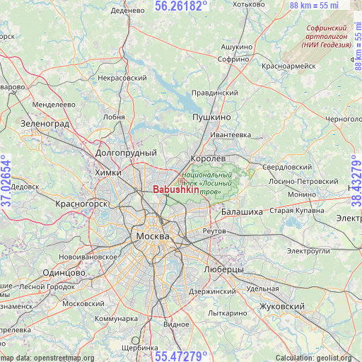
Babushkin GPS coordinates[2]
55° 52' 9.516" North, 37° 43' 46.776" East
| Map corner | latitude | longitude |
|---|---|---|
| Upper-left | 56.26182°, | 37.02654° |
| Center: | 55.86931°, | 37.72966° |
| Lower-right: | 55.47279°, | 38.43279° |
| Map W x H: | 87.7×87.7 km | = 54.5×54.5mi |
| max Lat: | 73.50819° ⇑35.3% North |
| Babushkin: | 55.86931° |
| min Lat: | ⇓64.7% South 41.28413° |
| min Long | Babushkin | max Long |
| -179.12198° | 37.72966° | 179.35046° |
| W 20.5%⇐ | ⇒79.5% E |
Elevation
Elevation of Babushkin is 158 m = 518 ft, and this is 44.6 m = 146 ft below average elevation for this country.
| Max E: |
2518 m = 8261 ft | 44.1% |
| Avg. | 202.6 m = 665 ft | |
| Babushkin | 158 m = 518 ft | |
Min E: |
-28 m = -92 ft | 55.9% |
See also: Babushkin elevation on elevation.city.
Geographical zone
Babushkin is located in North temperate zone (between Tropic of Cancer and the Arctic Circle). Distance of this North polar circle is 1189.1 km =738.9 mi to North.| Distance of | km | miles | from Babushkin |
|---|---|---|---|
| North Pole | 3795 | 2358.1 | to North |
| Arctic Circle | 1189.1 | 738.9 | to North |
| Tropic Cancer | 3606.2 | 2240.8 | to South |
| Equator | 6212.1 | 3860 | to South |


Nearby cities:
15 places around Babushkin: (largest is in red/bold)
• Bibirevo
8.2 km =5.1 mi,  280°
280°
• Bogorodskoye
6.3 km =3.9 mi,  187°
187°
• Druzhba
2 km =1.2 mi,  23°
23°
• Gol’yanovo
7.3 km =4.5 mi,  134°
134°
• Korolev
7.8 km =4.8 mi,  50°
50°
• Kozeyevo
7.1 km =4.4 mi,  267°
267°
• Leonovo
5.4 km =3.4 mi,  246°
246°
• Metrogorodok
7.6 km =4.7 mi,  151°
151°
• Mytishchi
4.7 km =2.9 mi,  0°
0°
• Otradnoye
8.1 km =5 mi, 267°
• Rostokino
5.6 km =3.5 mi,  224°
224°
• Sokol’niki
8.3 km =5.2 mi,  205°
205°
• Sviblovo
6.4 km =4 mi, 250°
• Vatutino
3 km =1.9 mi,  304°
304°
• Yaroslavskiy
1.8 km =1.1 mi,  332°
332°
Sources, notices
• [Note1] Compared only with cities in Russia existing in our database
• [Src1] Map data: © OpenStreetMap contributors (CC-BY-SA)
• [Src2] Other city data from geonames.org with taken over terms of usage.
• [Src3] Geographical zone / Annual Mean Temperature by Robert A. Rohde @ Wikipedia
