Gol’yanovo geodata
Gol’yanovo (Moscow) is a section of populated place; located in Russia in Europe/Moscow (GMT+3) time zone. With population of 158,000 people, there are 123 cities with bigger population in this country. Compared to other cities in Russia, 64% of cities are located further ↓South; 78.8% of cities are located further →East and 55.3% of cities have lower elevation than Gol’yanovo. Note1


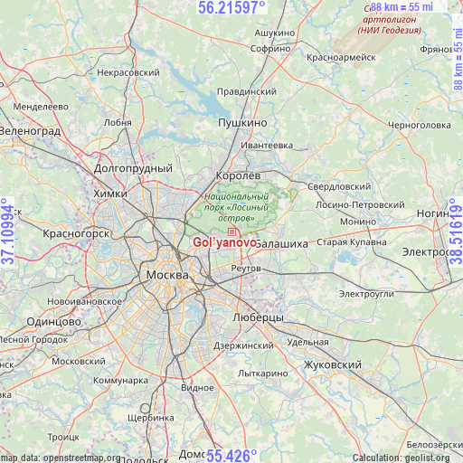
Gol’yanovo GPS coordinates[2]
55° 49' 22.764" North, 37° 48' 47.016" East
| Map corner | latitude | longitude |
|---|---|---|
| Upper-left | 56.21597°, | 37.10994° |
| Center: | 55.82299°, | 37.81306° |
| Lower-right: | 55.426°, | 38.51619° |
| Map W x H: | 87.8×87.8 km | = 54.6×54.6mi |
| max Lat: | 73.50819° ⇑36% North |
| Gol’yanovo: | 55.82299° |
| min Lat: | ⇓64% South 41.28413° |
| min Long | Gol’yanovo | max Long |
| -179.12198° | 37.81306° | 179.35046° |
| W 21.2%⇐ | ⇒78.8% E |
Elevation
Elevation of Gol’yanovo is 157 m = 515 ft, and this is 45.6 m = 150 ft below average elevation for this country.
| Max E: |
2518 m = 8261 ft | 44.7% |
| Avg. | 202.6 m = 665 ft | |
| Gol’yanovo | 157 m = 515 ft | |
Min E: |
-28 m = -92 ft | 55.3% |
See also: Gol’yanovo elevation on elevation.city.
Geographical zone
Gol’yanovo is located in North temperate zone (between Tropic of Cancer and the Arctic Circle). Distance of this North polar circle is 1194.2 km =742 mi to North.| Distance of | km | miles | from Gol’yanovo |
|---|---|---|---|
| North Pole | 3800.1 | 2361.3 | to North |
| Arctic Circle | 1194.2 | 742 | to North |
| Tropic Cancer | 3601 | 2237.6 | to South |
| Equator | 6206.9 | 3856.8 | to South |


Nearby cities:
15 places around Gol’yanovo: (largest is in red/bold)
• Babushkin
7.3 km =4.5 mi,  314°
314°
• Balashikha
9.2 km =5.7 mi,  99°
99°
• Bogorodskoye
6.1 km =3.8 mi,  260°
260°
• Druzhba
8.3 km =5.2 mi,  327°
327°
• Ivanovskoye
6.4 km =4 mi,  168°
168°
• Izmaylovo
4.1 km =2.5 mi,  190°
190°
• Lefortovo
9.4 km =5.8 mi,  228°
228°
• Metrogorodok
2.2 km =1.4 mi, 227°
• Novogireyevo
7.7 km =4.8 mi,  177°
177°
• Reutov
7.4 km =4.6 mi,  158°
158°
• Rostokino
9.2 km =5.7 mi,  277°
277°
• Saltykovka
9.9 km =6.2 mi,  129°
129°
• Sokol’niki
9.1 km =5.7 mi, 255°
• Vostochnyy
3.4 km =2.1 mi, 101°
• Yaroslavskiy
9 km =5.6 mi,  318°
318°
Sources, notices
• [Note1] Compared only with cities in Russia existing in our database
• [Src1] Map data: © OpenStreetMap contributors (CC-BY-SA)
• [Src2] Other city data from geonames.org with taken over terms of usage.
• [Src3] Geographical zone / Annual Mean Temperature by Robert A. Rohde @ Wikipedia
