Aleksandrovskoye geodata
Aleksandrovskoye (Stavropol’ Kray) is a populated place; located in Russia in Europe/Moscow (GMT+3) time zone. With population of 28,006 people, there are 700 cities with bigger population in this country. Compared to other cities in Russia, 88.8% of cities are located further ↑North; 56.9% of cities are located further →East and 83.6% of cities have lower elevation than Aleksandrovskoye. Note1


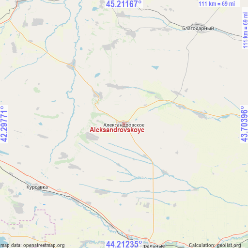
Aleksandrovskoye GPS coordinates[2]
44° 42' 51.012" North, 43° 0' 2.988" East
| Map corner | latitude | longitude |
|---|---|---|
| Upper-left | 45.21167°, | 42.29771° |
| Center: | 44.71417°, | 43.00083° |
| Lower-right: | 44.21235°, | 43.70396° |
| Map W x H: | 111.1×111.1 km | = 69×69mi |
| max Lat: | 73.50819° ⇑88.8% North |
| Aleksandrovskoye: | 44.71417° |
| min Lat: | ⇓11.2% South 41.28413° |
| min Long | Aleksandrovskoy | max Long |
| -179.12198° | 43.00083° | 179.35046° |
| W 43.1%⇐ | ⇒56.9% E |
Elevation
Elevation of Aleksandrovskoye is 295 m = 968 ft, and this is 92.4 m = 303 ft above average elevation for this country.
| Max E: |
2518 m = 8261 ft | 16.4% |
| Aleksandrovskoye | 295 m 968 ft | |
| Avg. | 202.6 m = 665 ft | |
Min E: |
-28 m = -92 ft | 83.6% |
See also: Russia elevation on elevation.city.
Geographical zone
Aleksandrovskoye is located in North temperate zone (between Tropic of Cancer and the Arctic Circle). Distance of this Northern Tropic circle is 2365.8 km =1470 mi to South.| Distance of | km | miles | from Aleksandrovskoye |
|---|---|---|---|
| North Pole | 5035.3 | 3128.8 | to North |
| Arctic Circle | 2429.4 | 1509.6 | to North |
| Tropic Cancer | 2365.8 | 1470 | to South |
| Equator | 4971.7 | 3089.3 | to South |


Nearby cities:
15 places around Aleksandrovskoye: (largest is in red/bold)
• Aleksandriya
46.5 km =28.9 mi,  24°
24°
• Andzhiyevskiy
53.3 km =33.1 mi,  172°
172°
• Gofitskoye
40.7 km =25.3 mi,  5°
5°
• Grecheskoye
31.5 km =19.6 mi,  178°
178°
• Kalinovskoye
16.9 km =10.5 mi,  349°
349°
• Kangly
51.2 km =31.8 mi, 177°
• Kruglolesskoye
16 km =9.9 mi,  247°
247°
• Kursavka
48.3 km =30 mi,  233°
233°
• Nagutskoye
31.9 km =19.8 mi,  198°
198°
• Novoselitskoye
34.7 km =21.6 mi,  83°
83°
• Severnoye
17.3 km =10.7 mi,  319°
319°
• Soluno-Dmitriyevskoye
40.6 km =25.2 mi,  212°
212°
• Sukhaya Buyvola
48.8 km =30.3 mi,  359°
359°
• Vysotskoye
35.4 km =22 mi, 347°
• Yelizavetinskoye
42.6 km =26.5 mi,  40°
40°
Sources, notices
• [Note1] Compared only with cities in Russia existing in our database
• [Src1] Map data: © OpenStreetMap contributors (CC-BY-SA)
• [Src2] Other city data from geonames.org with taken over terms of usage.
• [Src3] Geographical zone / Annual Mean Temperature by Robert A. Rohde @ Wikipedia
