Nagutskoye geodata
Nagutskoye (Stavropol’ Kray) is a populated place; located in Russia in Europe/Moscow (GMT+3) time zone. With population of 3,146 people, there are 3650 cities with bigger population in this country. Compared to other cities in Russia, 89.6% of cities are located further ↑North; 57.2% of cities are located further →East and 90% of cities have lower elevation than Nagutskoye. Note1


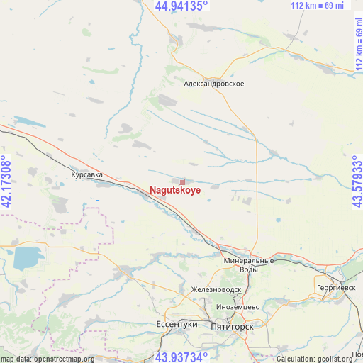
Nagutskoye GPS coordinates[2]
44° 26' 29.4" North, 42° 52' 34.32" East
| Map corner | latitude | longitude |
|---|---|---|
| Upper-left | 44.94135°, | 42.17308° |
| Center: | 44.4415°, | 42.8762° |
| Lower-right: | 43.93734°, | 43.57933° |
| Map W x H: | 111.6×111.6 km | = 69.3×69.3mi |
| max Lat: | 73.50819° ⇑89.6% North |
| Nagutskoye: | 44.4415° |
| min Lat: | ⇓10.4% South 41.28413° |
| min Long | Nagutskoye | max Long |
| -179.12198° | 42.8762° | 179.35046° |
| W 42.8%⇐ | ⇒57.2% E |
Elevation
Elevation of Nagutskoye is 451 m = 1480 ft, and this is 248.4 m = 815 ft above average elevation for this country.
| Max E: |
2518 m = 8261 ft | 10% |
| Nagutskoye | 451 m 1480 ft | |
| Avg. | 202.6 m = 665 ft | |
Min E: |
-28 m = -92 ft | 90% |
See also: Russia elevation on elevation.city.
Geographical zone
Nagutskoye is located in North temperate zone (between Tropic of Cancer and the Arctic Circle). Distance of this Northern Tropic circle is 2335.5 km =1451.2 mi to South.| Distance of | km | miles | from Nagutskoye |
|---|---|---|---|
| North Pole | 5065.6 | 3147.6 | to North |
| Arctic Circle | 2459.7 | 1528.4 | to North |
| Tropic Cancer | 2335.5 | 1451.2 | to South |
| Equator | 4941.4 | 3070.4 | to South |


Nearby cities:
15 places around Nagutskoye: (largest is in red/bold)
• Aleksandrovskoye
31.9 km =19.8 mi,  18°
18°
• Andzhiyevskiy
28 km =17.4 mi,  143°
143°
• Grazhdanskoye
25 km =15.5 mi,  199°
199°
• Grecheskoye
10.6 km =6.6 mi,  96°
96°
• Kangly
24.2 km =15 mi,  149°
149°
• Kruglolesskoye
24.7 km =15.3 mi,  348°
348°
• Kursavka
29.2 km =18.1 mi,  273°
273°
• Levokumka
31.9 km =19.8 mi, 136°
• Mineralnye Vody
32.9 km =20.4 mi, 141°
• Novoblagodarnoye
33.2 km =20.6 mi,  180°
180°
• Novoterskiy
36.8 km =22.9 mi, 152°
• Soluno-Dmitriyevskoye
12.7 km =7.9 mi,  252°
252°
• Suvorovskaya
32.8 km =20.4 mi,  211°
211°
• Udarnyy
31.2 km =19.4 mi, 250°
• Zheleznovodsk
35.5 km =22.1 mi,  161°
161°
Sources, notices
• [Note1] Compared only with cities in Russia existing in our database
• [Src1] Map data: © OpenStreetMap contributors (CC-BY-SA)
• [Src2] Other city data from geonames.org with taken over terms of usage.
• [Src3] Geographical zone / Annual Mean Temperature by Robert A. Rohde @ Wikipedia
