Kursavka geodata
Kursavka (Stavropol’ Kray) is a populated place; located in Russia in Europe/Moscow (GMT+3) time zone. With population of 11,043 people, there are 1370 cities with bigger population in this country. Compared to other cities in Russia, 89.6% of cities are located further ↑North; 58.3% of cities are located further →East and 88% of cities have lower elevation than Kursavka. Note1


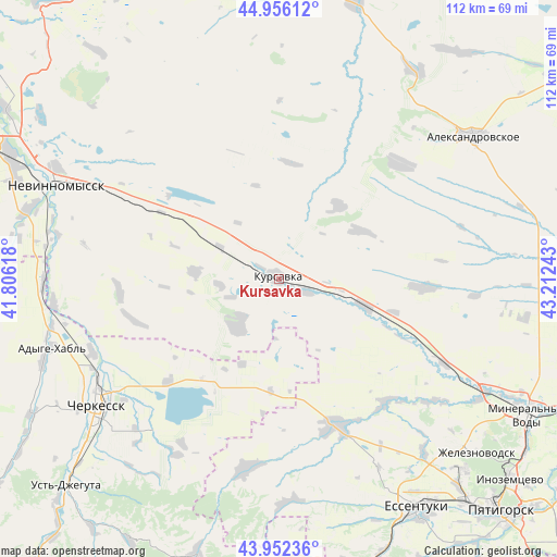
Kursavka GPS coordinates[2]
44° 27' 23.04" North, 42° 30' 33.48" East
| Map corner | latitude | longitude |
|---|---|---|
| Upper-left | 44.95612°, | 41.80618° |
| Center: | 44.4564°, | 42.5093° |
| Lower-right: | 43.95236°, | 43.21243° |
| Map W x H: | 111.6×111.6 km | = 69.3×69.3mi |
| max Lat: | 73.50819° ⇑89.6% North |
| Kursavka: | 44.4564° |
| min Lat: | ⇓10.4% South 41.28413° |
| min Long | Kursavka | max Long |
| -179.12198° | 42.5093° | 179.35046° |
| W 41.7%⇐ | ⇒58.3% E |
Elevation
Elevation of Kursavka is 398 m = 1306 ft, and this is 195.4 m = 641 ft above average elevation for this country.
| Max E: |
2518 m = 8261 ft | 12% |
| Kursavka | 398 m 1306 ft | |
| Avg. | 202.6 m = 665 ft | |
Min E: |
-28 m = -92 ft | 88% |
See also: Russia elevation on elevation.city.
Geographical zone
Kursavka is located in North temperate zone (between Tropic of Cancer and the Arctic Circle). Distance of this Northern Tropic circle is 2337.2 km =1452.3 mi to South.| Distance of | km | miles | from Kursavka |
|---|---|---|---|
| North Pole | 5064 | 3146.6 | to North |
| Arctic Circle | 2458.1 | 1527.4 | to North |
| Tropic Cancer | 2337.2 | 1452.3 | to South |
| Equator | 4943.1 | 3071.5 | to South |


Nearby cities:
15 places around Kursavka: (largest is in red/bold)
• Adyge-Khabl’
47.3 km =29.4 mi,  253°
253°
• Bekeshevskaya
38.6 km =24 mi,  189°
189°
• Borgustanskaya
44.7 km =27.8 mi,  178°
178°
• Cherkessk
44.3 km =27.5 mi,  234°
234°
• Grazhdanskoye
32.6 km =20.3 mi,  140°
140°
• Grecheskoye
39.7 km =24.7 mi,  94°
94°
• Kangly
47.2 km =29.3 mi,  118°
118°
• Kavkazskiy
30.3 km =18.8 mi, 226°
• Kruglolesskoye
33 km =20.5 mi,  47°
47°
• Nagutskoye
29.2 km =18.1 mi, 93°
• Novoblagodarnoye
45.4 km =28.2 mi, 140°
• Psyzh
46.3 km =28.8 mi,  237°
237°
• Soluno-Dmitriyevskoye
17.9 km =11.1 mi,  107°
107°
• Suvorovskaya
31.9 km =19.8 mi,  158°
158°
• Udarnyy
11.9 km =7.4 mi, 181°
Sources, notices
• [Note1] Compared only with cities in Russia existing in our database
• [Src1] Map data: © OpenStreetMap contributors (CC-BY-SA)
• [Src2] Other city data from geonames.org with taken over terms of usage.
• [Src3] Geographical zone / Annual Mean Temperature by Robert A. Rohde @ Wikipedia
