Yuzhnoural’sk geodata
Yuzhnoural’sk (Chelyabinsk) is a populated place; located in Russia in Asia/Yekaterinburg (GMT+5) time zone. With population of 39,200 people, there are 535 cities with bigger population in this country. Compared to other cities in Russia, 51.5% of cities are located further ↑North; 73.5% of cities are located further ←West and 78.6% of cities have lower elevation than Yuzhnoural’sk. Note1


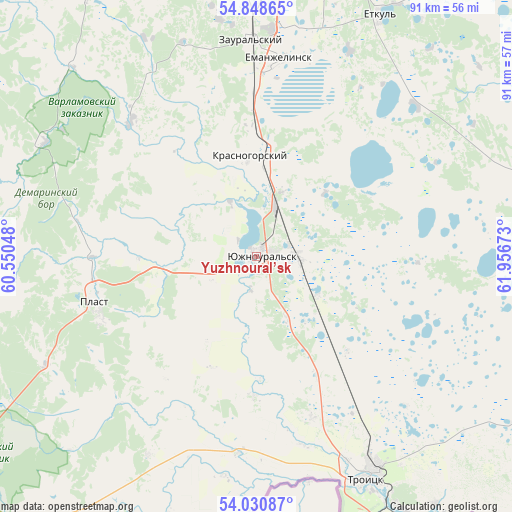
Yuzhnoural’sk GPS coordinates[2]
54° 26' 30.48" North, 61° 15' 12.96" East
| Map corner | latitude | longitude |
|---|---|---|
| Upper-left | 54.84865°, | 60.55048° |
| Center: | 54.4418°, | 61.2536° |
| Lower-right: | 54.03087°, | 61.95673° |
| Map W x H: | 90.9×90.9 km | = 56.5×56.5mi |
| max Lat: | 73.50819° ⇑51.5% North |
| Yuzhnoural’sk: | 54.4418° |
| min Lat: | ⇓48.5% South 41.28413° |
| min Long | Yuzhnoural’sk | max Long |
| -179.12198° | 61.2536° | 179.35046° |
| W 73.5%⇐ | ⇒26.5% E |
Elevation
Elevation of Yuzhnoural’sk is 238 m = 781 ft, and this is 35.4 m = 116 ft above average elevation for this country.
| Max E: |
2518 m = 8261 ft | 21.4% |
| Yuzhnoural’sk | 238 m 781 ft | |
| Avg. | 202.6 m = 665 ft | |
Min E: |
-28 m = -92 ft | 78.6% |
See also: Russia elevation on elevation.city.
Geographical zone
Yuzhnoural’sk is located in North temperate zone (between Tropic of Cancer and the Arctic Circle). Distance of this North polar circle is 1347.8 km =837.5 mi to North.| Distance of | km | miles | from Yuzhnoural’sk |
|---|---|---|---|
| North Pole | 3953.7 | 2456.7 | to North |
| Arctic Circle | 1347.8 | 837.5 | to North |
| Tropic Cancer | 3447.4 | 2142.1 | to South |
| Equator | 6053.4 | 3761.4 | to South |


Nearby cities:
15 places around Yuzhnoural’sk: (largest is in red/bold)
• Berlin
48.6 km =30.2 mi,  184°
184°
• Bobrovka
54.3 km =33.7 mi,  143°
143°
• Korkino
50.8 km =31.6 mi,  10°
10°
• Koyelga
32.5 km =20.2 mi,  316°
316°
• Krasnogorskiy
17.9 km =11.1 mi,  355°
355°
• Plast
29.6 km =18.4 mi,  254°
254°
• Roza
54.4 km =33.8 mi, 14°
• Sargazy
64.4 km =40 mi, 359°
• Selezyan
63.3 km =39.3 mi,  35°
35°
• Timiryazevskiy
62.7 km =39 mi,  329°
329°
• Troitsk
43.6 km =27.1 mi,  151°
151°
• Uvel’skiy
6.7 km =4.2 mi,  87°
87°
• Yemanzhelinka
40 km =24.9 mi,  4°
4°
• Yemanzhelinsk
35.1 km =21.8 mi, 7°
• Yetkul’
47.4 km =29.5 mi,  26°
26°
Sources, notices
• [Note1] Compared only with cities in Russia existing in our database
• [Src1] Map data: © OpenStreetMap contributors (CC-BY-SA)
• [Src2] Other city data from geonames.org with taken over terms of usage.
• [Src3] Geographical zone / Annual Mean Temperature by Robert A. Rohde @ Wikipedia
