Koyelga geodata
Koyelga (Chelyabinsk) is a populated place; located in Russia in Asia/Yekaterinburg (GMT+5) time zone. With population of 4,053 people, there are 3081 cities with bigger population in this country. Compared to other cities in Russia, 50.1% of cities are located further ↓South; 73.2% of cities are located further ←West and 78.1% of cities have lower elevation than Koyelga. Note1


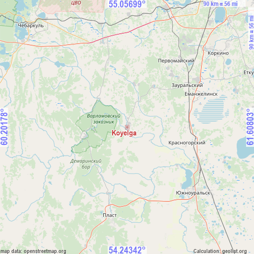
Koyelga GPS coordinates[2]
54° 39' 8.064" North, 60° 54' 17.64" East
| Map corner | latitude | longitude |
|---|---|---|
| Upper-left | 55.05699°, | 60.20178° |
| Center: | 54.65224°, | 60.9049° |
| Lower-right: | 54.24342°, | 61.60803° |
| Map W x H: | 90.5×90.5 km | = 56.2×56.2mi |
| max Lat: | 73.50819° ⇑49.9% North |
| Koyelga: | 54.65224° |
| min Lat: | ⇓50.1% South 41.28413° |
| min Long | Koyelga | max Long |
| -179.12198° | 60.9049° | 179.35046° |
| W 73.2%⇐ | ⇒26.8% E |
Elevation
Elevation of Koyelga is 235 m = 771 ft, and this is 32.4 m = 106 ft above average elevation for this country.
| Max E: |
2518 m = 8261 ft | 21.9% |
| Koyelga | 235 m 771 ft | |
| Avg. | 202.6 m = 665 ft | |
Min E: |
-28 m = -92 ft | 78.1% |
See also: Russia elevation on elevation.city.
Geographical zone
Koyelga is located in North temperate zone (between Tropic of Cancer and the Arctic Circle). Distance of this North polar circle is 1324.4 km =822.9 mi to North.| Distance of | km | miles | from Koyelga |
|---|---|---|---|
| North Pole | 3930.3 | 2442.2 | to North |
| Arctic Circle | 1324.4 | 822.9 | to North |
| Tropic Cancer | 3470.8 | 2156.7 | to South |
| Equator | 6076.8 | 3775.9 | to South |


Nearby cities:
15 places around Koyelga: (largest is in red/bold)
• Chebarkul’
49.9 km =31 mi,  315°
315°
• Korkino
41.3 km =25.7 mi,  49°
49°
• Krasnogorskiy
21.7 km =13.5 mi,  104°
104°
• Novosineglazovskiy
52.6 km =32.7 mi,  35°
35°
• Plast
32 km =19.9 mi,  190°
190°
• Poletayevo
44.5 km =27.7 mi,  17°
17°
• Roza
46.1 km =28.6 mi, 50°
• Sargazy
46.5 km =28.9 mi,  28°
28°
• Starokamyshinsk
61.3 km =38.1 mi, 45°
• Timiryazevskiy
32.1 km =19.9 mi,  343°
343°
• Uvel’skiy
37.2 km =23.1 mi,  128°
128°
• Yemanzhelinka
30.2 km =18.8 mi,  56°
56°
• Yemanzhelinsk
29 km =18 mi,  66°
66°
• Yetkul’
47.7 km =29.6 mi, 66°
• Yuzhnoural’sk
32.5 km =20.2 mi,  136°
136°
Sources, notices
• [Note1] Compared only with cities in Russia existing in our database
• [Src1] Map data: © OpenStreetMap contributors (CC-BY-SA)
• [Src2] Other city data from geonames.org with taken over terms of usage.
• [Src3] Geographical zone / Annual Mean Temperature by Robert A. Rohde @ Wikipedia
