Uvel’skiy geodata
Uvel’skiy (Chelyabinsk) is a populated place; located in Russia in Asia/Yekaterinburg (GMT+5) time zone. With population of 11,293 people, there are 1340 cities with bigger population in this country. Compared to other cities in Russia, 51.4% of cities are located further ↑North; 73.6% of cities are located further ←West and 78.1% of cities have lower elevation than Uvel’skiy. Note1


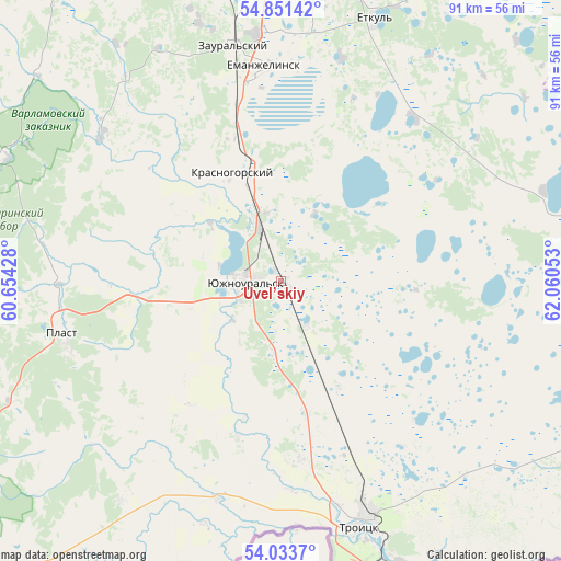
Uvel’skiy GPS coordinates[2]
54° 26' 40.56" North, 61° 21' 26.64" East
| Map corner | latitude | longitude |
|---|---|---|
| Upper-left | 54.85142°, | 60.65428° |
| Center: | 54.4446°, | 61.3574° |
| Lower-right: | 54.0337°, | 62.06053° |
| Map W x H: | 90.9×90.9 km | = 56.5×56.5mi |
| max Lat: | 73.50819° ⇑51.4% North |
| Uvel’skiy: | 54.4446° |
| min Lat: | ⇓48.6% South 41.28413° |
| min Long | Uvel’skiy | max Long |
| -179.12198° | 61.3574° | 179.35046° |
| W 73.6%⇐ | ⇒26.4% E |
Elevation
Elevation of Uvel’skiy is 235 m = 771 ft, and this is 32.4 m = 106 ft above average elevation for this country.
| Max E: |
2518 m = 8261 ft | 21.9% |
| Uvel’skiy | 235 m 771 ft | |
| Avg. | 202.6 m = 665 ft | |
Min E: |
-28 m = -92 ft | 78.1% |
See also: Russia elevation on elevation.city.
Geographical zone
Uvel’skiy is located in North temperate zone (between Tropic of Cancer and the Arctic Circle). Distance of this North polar circle is 1347.5 km =837.3 mi to North.| Distance of | km | miles | from Uvel’skiy |
|---|---|---|---|
| North Pole | 3953.4 | 2456.5 | to North |
| Arctic Circle | 1347.5 | 837.3 | to North |
| Tropic Cancer | 3447.8 | 2142.4 | to South |
| Equator | 6053.7 | 3761.6 | to South |


Nearby cities:
15 places around Uvel’skiy: (largest is in red/bold)
• Berlin
49.9 km =31 mi,  192°
192°
• Bobrovka
50.9 km =31.6 mi,  150°
150°
• Korkino
49.7 km =30.9 mi,  2°
2°
• Koyelga
37.2 km =23.1 mi,  308°
308°
• Krasnogorskiy
19.4 km =12.1 mi,  335°
335°
• Novosineglazovskiy
66.1 km =41.1 mi, 1°
• Plast
36.2 km =22.5 mi,  256°
256°
• Roza
52.9 km =32.9 mi,  7°
7°
• Sargazy
64.4 km =40 mi,  353°
353°
• Selezyan
59.4 km =36.9 mi,  30°
30°
• Troitsk
41.1 km =25.5 mi,  159°
159°
• Yemanzhelinka
39.8 km =24.7 mi, 354°
• Yemanzhelinsk
34.6 km =21.5 mi,  356°
356°
• Yetkul’
44.5 km =27.7 mi,  19°
19°
• Yuzhnoural’sk
6.7 km =4.2 mi,  267°
267°
Sources, notices
• [Note1] Compared only with cities in Russia existing in our database
• [Src1] Map data: © OpenStreetMap contributors (CC-BY-SA)
• [Src2] Other city data from geonames.org with taken over terms of usage.
• [Src3] Geographical zone / Annual Mean Temperature by Robert A. Rohde @ Wikipedia
