Yertarskiy geodata
Yertarskiy (Sverdlovsk) is a populated place; located in Russia in Asia/Yekaterinburg (GMT+5) time zone. With population of 1,612 people, there are 4330 cities with bigger population in this country. Compared to other cities in Russia, 75.2% of cities are located further ↓South; 75.4% of cities are located further ←West and 76.7% of cities have higher elevation than Yertarskiy. Note1


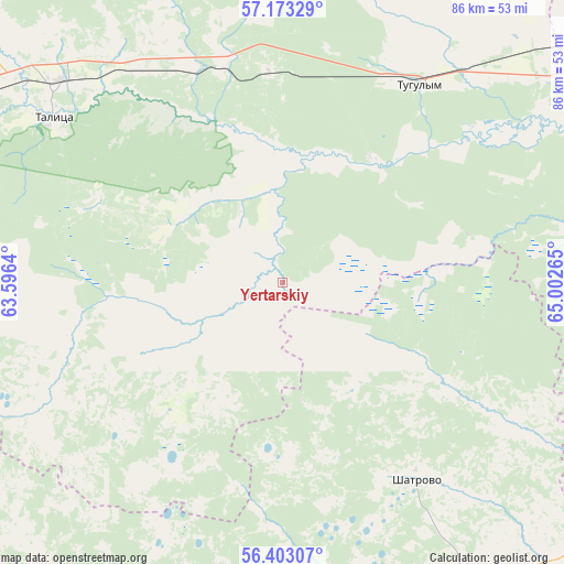
Yertarskiy GPS coordinates[2]
56° 47' 24.576" North, 64° 17' 58.272" East
| Map corner | latitude | longitude |
|---|---|---|
| Upper-left | 57.17329°, | 63.5964° |
| Center: | 56.79016°, | 64.29952° |
| Lower-right: | 56.40307°, | 65.00265° |
| Map W x H: | 85.6×85.6 km | = 53.2×53.2mi |
| max Lat: | 73.50819° ⇑24.8% North |
| Yertarskiy: | 56.79016° |
| min Lat: | ⇓75.2% South 41.28413° |
| min Long | Yertarskiy | max Long |
| -179.12198° | 64.29952° | 179.35046° |
| W 75.4%⇐ | ⇒24.6% E |
Elevation
Elevation of Yertarskiy is 82 m = 269 ft, and this is 120.6 m = 396 ft below average elevation for this country.
| Max E: |
2518 m = 8261 ft | 76.7% |
| Avg. | 202.6 m = 665 ft | |
| Yertarskiy | 82 m = 269 ft | |
Min E: |
-28 m = -92 ft | 23.3% |
See also: Russia elevation on elevation.city.
Geographical zone
Yertarskiy is located in North temperate zone (between Tropic of Cancer and the Arctic Circle). Distance of this North polar circle is 1086.7 km =675.2 mi to North.| Distance of | km | miles | from Yertarskiy |
|---|---|---|---|
| North Pole | 3692.6 | 2294.5 | to North |
| Arctic Circle | 1086.7 | 675.2 | to North |
| Tropic Cancer | 3708.6 | 2304.4 | to South |
| Equator | 6314.5 | 3923.6 | to South |


Nearby cities:
15 places around Yertarskiy: (largest is in red/bold)
• Baykalovo
74.8 km =46.5 mi,  334°
334°
• Butka
32.3 km =20.1 mi,  255°
255°
• Cheremysh
76.1 km =47.3 mi,  275°
275°
• Chervishevo
70.7 km =43.9 mi,  75°
75°
• Isetskoye
71.1 km =44.2 mi,  118°
118°
• Lugovskoy
23.3 km =14.5 mi,  36°
36°
• Moskovskiy
76.9 km =47.8 mi,  62°
62°
• Onokhino
76.8 km =47.7 mi, 78°
• Pyshma
66.2 km =41.1 mi,  285°
285°
• Shatrovo
36.3 km =22.6 mi,  145°
145°
• Talitsa
42.3 km =26.3 mi,  305°
305°
• Troitskiy
45 km =28 mi, 311°
• Tugulym
36.4 km =22.6 mi,  34°
34°
• Yushala
31.9 km =19.8 mi,  355°
355°
• Zavodouspenskoye
44.3 km =27.5 mi, 79°
Sources, notices
• [Note1] Compared only with cities in Russia existing in our database
• [Src1] Map data: © OpenStreetMap contributors (CC-BY-SA)
• [Src2] Other city data from geonames.org with taken over terms of usage.
• [Src3] Geographical zone / Annual Mean Temperature by Robert A. Rohde @ Wikipedia
