Yushala geodata
Yushala (Sverdlovsk) is a populated place; located in Russia in Asia/Yekaterinburg (GMT+5) time zone. With population of 4,169 people, there are 3021 cities with bigger population in this country. Compared to other cities in Russia, 77.8% of cities are located further ↓South; 75.4% of cities are located further ←West and 65.7% of cities have higher elevation than Yushala. Note1


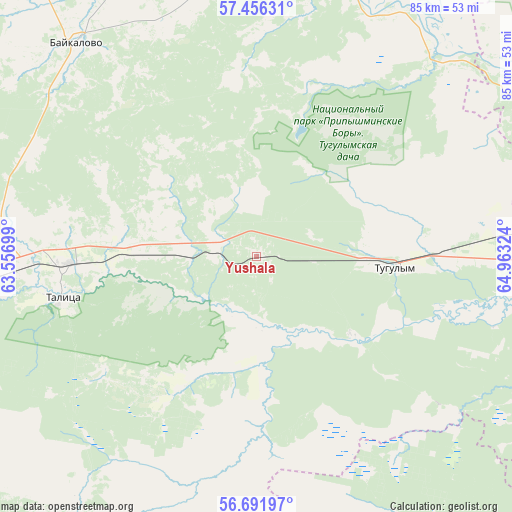
Yushala GPS coordinates[2]
57° 4' 33.996" North, 64° 15' 36.396" East
| Map corner | latitude | longitude |
|---|---|---|
| Upper-left | 57.45631°, | 63.55699° |
| Center: | 57.07611°, | 64.26011° |
| Lower-right: | 56.69197°, | 64.96324° |
| Map W x H: | 85×85 km | = 52.8×52.8mi |
| max Lat: | 73.50819° ⇑22.2% North |
| Yushala: | 57.07611° |
| min Lat: | ⇓77.8% South 41.28413° |
| min Long | Yushala | max Long |
| -179.12198° | 64.26011° | 179.35046° |
| W 75.4%⇐ | ⇒24.6% E |
Elevation
Elevation of Yushala is 112 m = 367 ft, and this is 90.6 m = 297 ft below average elevation for this country.
| Max E: |
2518 m = 8261 ft | 65.7% |
| Avg. | 202.6 m = 665 ft | |
| Yushala | 112 m = 367 ft | |
Min E: |
-28 m = -92 ft | 34.3% |
See also: Russia elevation on elevation.city.
Geographical zone
Yushala is located in North temperate zone (between Tropic of Cancer and the Arctic Circle). Distance of this North polar circle is 1054.9 km =655.5 mi to North.| Distance of | km | miles | from Yushala |
|---|---|---|---|
| North Pole | 3660.8 | 2274.7 | to North |
| Arctic Circle | 1054.9 | 655.5 | to North |
| Tropic Cancer | 3740.3 | 2324.1 | to South |
| Equator | 6346.3 | 3943.4 | to South |


Nearby cities:
15 places around Yushala: (largest is in red/bold)
• Baykalovo
46.4 km =28.8 mi,  320°
320°
• Butka
49.1 km =30.5 mi,  215°
215°
• Cheremysh
77 km =47.8 mi,  251°
251°
• Chervishevo
72.1 km =44.8 mi,  101°
101°
• Lugovskoy
20.9 km =13 mi,  128°
128°
• Moskovskiy
70.4 km =43.7 mi,  86°
86°
• Pyshma
62.6 km =38.9 mi,  257°
257°
• Shatrovo
65.9 km =40.9 mi,  159°
159°
• Talitsa
32.7 km =20.3 mi, 257°
• Troitskiy
31 km =19.3 mi,  266°
266°
• Tugulym
23.2 km =14.4 mi, 94°
• Turinskaya Sloboda
61.3 km =38.1 mi,  7°
7°
• Tyumen
77 km =47.8 mi,  83°
83°
• Yertarskiy
31.9 km =19.8 mi,  175°
175°
• Zavodouspenskoye
51.6 km =32.1 mi,  117°
117°
Sources, notices
• [Note1] Compared only with cities in Russia existing in our database
• [Src1] Map data: © OpenStreetMap contributors (CC-BY-SA)
• [Src2] Other city data from geonames.org with taken over terms of usage.
• [Src3] Geographical zone / Annual Mean Temperature by Robert A. Rohde @ Wikipedia
