Shatrovo geodata
Shatrovo (Kurgan Oblast) is a populated place; located in Russia in Asia/Yekaterinburg (GMT+5) time zone. With population of 6,295 people, there are 2179 cities with bigger population in this country. Compared to other cities in Russia, 72.9% of cities are located further ↓South; 75.6% of cities are located further ←West and 65% of cities have higher elevation than Shatrovo. Note1


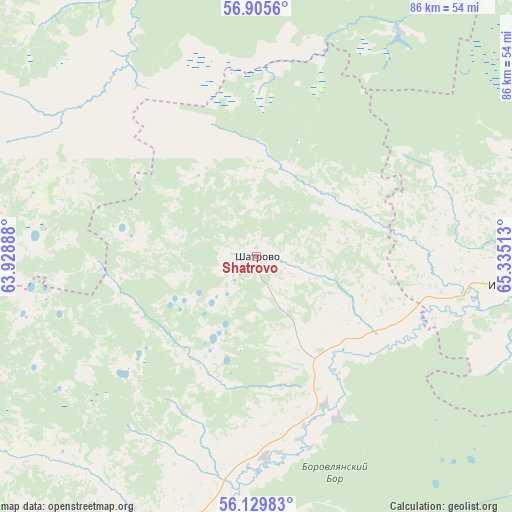
Shatrovo GPS coordinates[2]
56° 31' 10.92" North, 64° 37' 55.2" East
| Map corner | latitude | longitude |
|---|---|---|
| Upper-left | 56.9056°, | 63.92888° |
| Center: | 56.5197°, | 64.632° |
| Lower-right: | 56.12983°, | 65.33513° |
| Map W x H: | 86.3×86.3 km | = 53.6×53.6mi |
| max Lat: | 73.50819° ⇑27.1% North |
| Shatrovo: | 56.5197° |
| min Lat: | ⇓72.9% South 41.28413° |
| min Long | Shatrovo | max Long |
| -179.12198° | 64.632° | 179.35046° |
| W 75.6%⇐ | ⇒24.4% E |
Elevation
Elevation of Shatrovo is 114 m = 374 ft, and this is 88.6 m = 291 ft below average elevation for this country.
| Max E: |
2518 m = 8261 ft | 65% |
| Avg. | 202.6 m = 665 ft | |
| Shatrovo | 114 m = 374 ft | |
Min E: |
-28 m = -92 ft | 35% |
See also: Russia elevation on elevation.city.
Geographical zone
Shatrovo is located in North temperate zone (between Tropic of Cancer and the Arctic Circle). Distance of this North polar circle is 1116.8 km =693.9 mi to North.| Distance of | km | miles | from Shatrovo |
|---|---|---|---|
| North Pole | 3722.7 | 2313.2 | to North |
| Arctic Circle | 1116.8 | 693.9 | to North |
| Tropic Cancer | 3678.5 | 2285.7 | to South |
| Equator | 6284.4 | 3904.9 | to South |


Nearby cities:
15 places around Shatrovo: (largest is in red/bold)
• Bogandinskiy
87.5 km =54.4 mi,  61°
61°
• Butka
56.2 km =34.9 mi,  293°
293°
• Chervishevo
67.9 km =42.2 mi,  45°
45°
• Isetskoye
42.5 km =26.4 mi,  95°
95°
• Lugovskoy
49.2 km =30.6 mi,  352°
352°
• Moskovskiy
81.5 km =50.6 mi,  36°
36°
• Onokhino
71.4 km =44.4 mi, 50°
• Shadrinsk
78.3 km =48.7 mi,  231°
231°
• Talitsa
77.4 km =48.1 mi,  314°
314°
• Troitskiy
80.7 km =50.1 mi,  318°
318°
• Tugulym
60 km =37.3 mi,  0°
0°
• Vinzili
84.9 km =52.8 mi, 54°
• Yertarskiy
36.3 km =22.6 mi,  325°
325°
• Yushala
65.9 km =40.9 mi,  339°
339°
• Zavodouspenskoye
44.7 km =27.8 mi,  31°
31°
Sources, notices
• [Note1] Compared only with cities in Russia existing in our database
• [Src1] Map data: © OpenStreetMap contributors (CC-BY-SA)
• [Src2] Other city data from geonames.org with taken over terms of usage.
• [Src3] Geographical zone / Annual Mean Temperature by Robert A. Rohde @ Wikipedia
