Vlasikha geodata
Vlasikha (Altai Krai) is a populated place; located in Russia in Asia/Barnaul (GMT+7) time zone. With population of 4,687 people, there are 2788 cities with bigger population in this country. Compared to other cities in Russia, 60.4% of cities are located further ↑North; 81% of cities are located further ←West and 62.9% of cities have lower elevation than Vlasikha. Note1


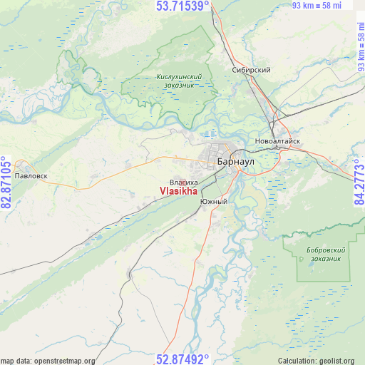
Vlasikha GPS coordinates[2]
53° 17' 49.992" North, 83° 34' 27.012" East
| Map corner | latitude | longitude |
|---|---|---|
| Upper-left | 53.71539°, | 82.87105° |
| Center: | 53.29722°, | 83.57417° |
| Lower-right: | 52.87492°, | 84.2773° |
| Map W x H: | 93.5×93.4 km | = 58.1×58mi |
| max Lat: | 73.50819° ⇑60.4% North |
| Vlasikha: | 53.29722° |
| min Lat: | ⇓39.6% South 41.28413° |
| min Long | Vlasikha | max Long |
| -179.12198° | 83.57417° | 179.35046° |
| W 81%⇐ | ⇒19% E |
Elevation
Elevation of Vlasikha is 176 m = 577 ft, and this is 26.6 m = 87 ft below average elevation for this country.
| Max E: |
2518 m = 8261 ft | 37.1% |
| Avg. | 202.6 m = 665 ft | |
| Vlasikha | 176 m = 577 ft | |
Min E: |
-28 m = -92 ft | 62.9% |
See also: Russia elevation on elevation.city.
Geographical zone
Vlasikha is located in North temperate zone (between Tropic of Cancer and the Arctic Circle). Distance of this North polar circle is 1475.1 km =916.6 mi to North.| Distance of | km | miles | from Vlasikha |
|---|---|---|---|
| North Pole | 4081 | 2535.8 | to North |
| Arctic Circle | 1475.1 | 916.6 | to North |
| Tropic Cancer | 3320.2 | 2063.1 | to South |
| Equator | 5926.1 | 3682.3 | to South |


Nearby cities:
15 places around Vlasikha: (largest is in red/bold)
• Barnaul
14.4 km =8.9 mi,  60°
60°
• Bobrovka
23.7 km =14.7 mi,  122°
122°
• Chernitsk
10 km =6.2 mi,  188°
188°
• Firsovo
25.3 km =15.7 mi,  84°
84°
• Gon’ba
13.3 km =8.3 mi,  0°
0°
• Lebyazh’ye
8 km =5 mi,  138°
138°
• Mokhnatushka
7.5 km =4.7 mi,  177°
177°
• Nauchnyy Gorodok
14.1 km =8.8 mi,  345°
345°
• Novomikhaylovka
8.7 km =5.4 mi,  312°
312°
• Novosilikatnyy
3.6 km =2.2 mi,  67°
67°
• Novyye Zori
11.3 km =7 mi,  241°
241°
• Shakhi
14.7 km =9.1 mi,  287°
287°
• Stukovo
18.3 km =11.4 mi, 239°
• Yuzhnyy
9.3 km =5.8 mi, 121°
• Zaton
15.5 km =9.6 mi,  91°
91°
Sources, notices
• [Note1] Compared only with cities in Russia existing in our database
• [Src1] Map data: © OpenStreetMap contributors (CC-BY-SA)
• [Src2] Other city data from geonames.org with taken over terms of usage.
• [Src3] Geographical zone / Annual Mean Temperature by Robert A. Rohde @ Wikipedia
