Gon’ba geodata
Gon’ba (Altai Krai) is a populated place; located in Russia in Asia/Barnaul (GMT+7) time zone. With population of 2,000 people, there are 4146 cities with bigger population in this country. Compared to other cities in Russia, 59.4% of cities are located further ↑North; 81% of cities are located further ←West and 58.2% of cities have lower elevation than Gon’ba. Note1


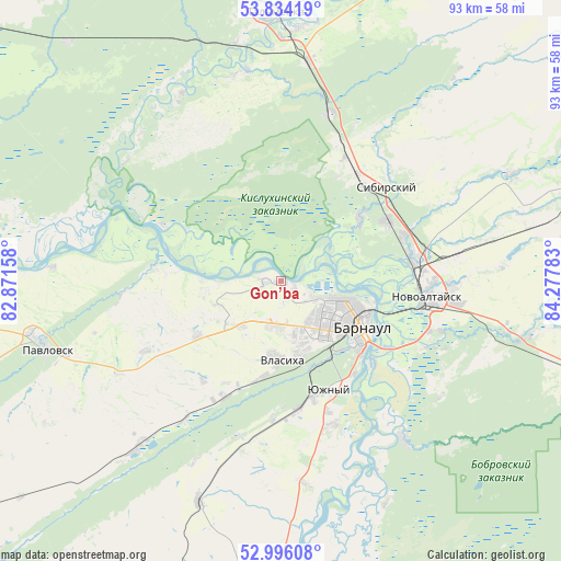
Gon’ba GPS coordinates[2]
53° 25' 1.92" North, 83° 34' 28.92" East
| Map corner | latitude | longitude |
|---|---|---|
| Upper-left | 53.83419°, | 82.87158° |
| Center: | 53.4172°, | 83.5747° |
| Lower-right: | 52.99608°, | 84.27783° |
| Map W x H: | 93.2×93.2 km | = 57.9×57.9mi |
| max Lat: | 73.50819° ⇑59.4% North |
| Gon’ba: | 53.4172° |
| min Lat: | ⇓40.6% South 41.28413° |
| min Long | Gon’ba | max Long |
| -179.12198° | 83.5747° | 179.35046° |
| W 81%⇐ | ⇒19% E |
Elevation
Elevation of Gon’ba is 164 m = 538 ft, and this is 38.6 m = 127 ft below average elevation for this country.
| Max E: |
2518 m = 8261 ft | 41.8% |
| Avg. | 202.6 m = 665 ft | |
| Gon’ba | 164 m = 538 ft | |
Min E: |
-28 m = -92 ft | 58.2% |
See also: Russia elevation on elevation.city.
Geographical zone
Gon’ba is located in North temperate zone (between Tropic of Cancer and the Arctic Circle). Distance of this North polar circle is 1461.7 km =908.3 mi to North.| Distance of | km | miles | from Gon’ba |
|---|---|---|---|
| North Pole | 4067.6 | 2527.5 | to North |
| Arctic Circle | 1461.7 | 908.3 | to North |
| Tropic Cancer | 3333.5 | 2071.3 | to South |
| Equator | 5939.4 | 3690.6 | to South |


Nearby cities:
15 places around Gon’ba: (largest is in red/bold)
• Barnaul
14 km =8.7 mi,  116°
116°
• Beloyarsk
22.1 km =13.7 mi,  81°
81°
• Borovikha
20.1 km =12.5 mi,  60°
60°
• Lebyazh’ye
20 km =12.4 mi,  164°
164°
• Mokhnatushka
20.9 km =13 mi,  179°
179°
• Nauchnyy Gorodok
3.6 km =2.2 mi,  275°
275°
• Novomikhaylovka
9.9 km =6.2 mi,  220°
220°
• Novosilikatnyy
12.4 km =7.7 mi, 164°
• Novyye Zori
21.3 km =13.2 mi,  207°
207°
• Shakhi
16.7 km =10.4 mi,  237°
237°
• Sibirskiy
21.6 km =13.4 mi,  34°
34°
• Vlasikha
13.3 km =8.3 mi, 180°
• Yuzhnyy
19.8 km =12.3 mi, 156°
• Zaton
20.7 km =12.9 mi,  131°
131°
• Zudilovo
22.7 km =14.1 mi,  68°
68°
Sources, notices
• [Note1] Compared only with cities in Russia existing in our database
• [Src1] Map data: © OpenStreetMap contributors (CC-BY-SA)
• [Src2] Other city data from geonames.org with taken over terms of usage.
• [Src3] Geographical zone / Annual Mean Temperature by Robert A. Rohde @ Wikipedia
