Zaton geodata
Zaton (Altai Krai) is a populated place; located in Russia in Asia/Barnaul (GMT+7) time zone. With population of 3,157 people, there are 3635 cities with bigger population in this country. Compared to other cities in Russia, 60.4% of cities are located further ↑North; 81.3% of cities are located further ←West and 56.2% of cities have higher elevation than Zaton. Note1


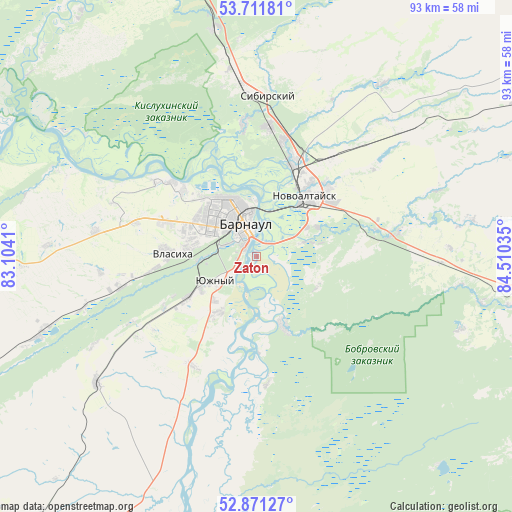
Zaton GPS coordinates[2]
53° 17' 36.996" North, 83° 48' 25.992" East
| Map corner | latitude | longitude |
|---|---|---|
| Upper-left | 53.71181°, | 83.1041° |
| Center: | 53.29361°, | 83.80722° |
| Lower-right: | 52.87127°, | 84.51035° |
| Map W x H: | 93.5×93.5 km | = 58.1×58.1mi |
| max Lat: | 73.50819° ⇑60.4% North |
| Zaton: | 53.29361° |
| min Lat: | ⇓39.6% South 41.28413° |
| min Long | Zaton | max Long |
| -179.12198° | 83.80722° | 179.35046° |
| W 81.3%⇐ | ⇒18.7% E |
Elevation
Elevation of Zaton is 132 m = 433 ft, and this is 70.6 m = 232 ft below average elevation for this country.
| Max E: |
2518 m = 8261 ft | 56.2% |
| Avg. | 202.6 m = 665 ft | |
| Zaton | 132 m = 433 ft | |
Min E: |
-28 m = -92 ft | 43.8% |
See also: Russia elevation on elevation.city.
Geographical zone
Zaton is located in North temperate zone (between Tropic of Cancer and the Arctic Circle). Distance of this North polar circle is 1475.5 km =916.8 mi to North.| Distance of | km | miles | from Zaton |
|---|---|---|---|
| North Pole | 4081.4 | 2536.1 | to North |
| Arctic Circle | 1475.5 | 916.8 | to North |
| Tropic Cancer | 3319.8 | 2062.8 | to South |
| Equator | 5925.7 | 3682.1 | to South |


Nearby cities:
15 places around Zaton: (largest is in red/bold)
• Barnaul
8 km =5 mi,  338°
338°
• Beloyarsk
18.1 km =11.2 mi,  20°
20°
• Bobrovka
13.1 km =8.1 mi,  159°
159°
• Chernitsk
19.4 km =12.1 mi,  240°
240°
• Firsovo
10.1 km =6.3 mi,  74°
74°
• Gon’ba
20.7 km =12.9 mi,  311°
311°
• Lebyazh’ye
11.6 km =7.2 mi, 241°
• Lesnoy
12.3 km =7.6 mi,  117°
117°
• Mokhnatushka
16.7 km =10.4 mi, 244°
• Novoaltaysk
13.9 km =8.6 mi,  38°
38°
• Novomikhaylovka
22.8 km =14.2 mi,  285°
285°
• Novosilikatnyy
12.3 km =7.6 mi,  278°
278°
• Sannikovo
12.5 km =7.8 mi,  62°
62°
• Vlasikha
15.5 km =9.6 mi,  271°
271°
• Yuzhnyy
8.7 km =5.4 mi, 239°
Sources, notices
• [Note1] Compared only with cities in Russia existing in our database
• [Src1] Map data: © OpenStreetMap contributors (CC-BY-SA)
• [Src2] Other city data from geonames.org with taken over terms of usage.
• [Src3] Geographical zone / Annual Mean Temperature by Robert A. Rohde @ Wikipedia
