Lebyazh’ye geodata
Lebyazh’ye (Altai Krai) is a populated place; located in Russia in Asia/Barnaul (GMT+7) time zone. With population of 4,595 people, there are 2825 cities with bigger population in this country. Compared to other cities in Russia, 61% of cities are located further ↑North; 81.1% of cities are located further ←West and 74.5% of cities have lower elevation than Lebyazh’ye. Note1


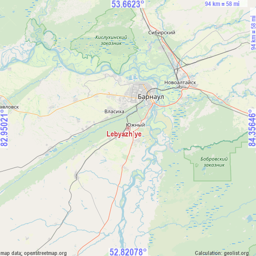
Lebyazh’ye GPS coordinates[2]
53° 14' 36.996" North, 83° 39' 11.988" East
| Map corner | latitude | longitude |
|---|---|---|
| Upper-left | 53.6623°, | 82.95021° |
| Center: | 53.24361°, | 83.65333° |
| Lower-right: | 52.82078°, | 84.35646° |
| Map W x H: | 93.6×93.6 km | = 58.2×58.2mi |
| max Lat: | 73.50819° ⇑61% North |
| Lebyazh’ye: | 53.24361° |
| min Lat: | ⇓39% South 41.28413° |
| min Long | Lebyazh’ye | max Long |
| -179.12198° | 83.65333° | 179.35046° |
| W 81.1%⇐ | ⇒18.9% E |
Elevation
Elevation of Lebyazh’ye is 214 m = 702 ft, and this is 11.4 m = 37 ft above average elevation for this country.
| Max E: |
2518 m = 8261 ft | 25.5% |
| Lebyazh’ye | 214 m 702 ft | |
| Avg. | 202.6 m = 665 ft | |
Min E: |
-28 m = -92 ft | 74.5% |
See also: Russia elevation on elevation.city.
Geographical zone
Lebyazh’ye is located in North temperate zone (between Tropic of Cancer and the Arctic Circle). Distance of this North polar circle is 1481 km =920.3 mi to North.| Distance of | km | miles | from Lebyazh’ye |
|---|---|---|---|
| North Pole | 4086.9 | 2539.5 | to North |
| Arctic Circle | 1481 | 920.3 | to North |
| Tropic Cancer | 3314.2 | 2059.3 | to South |
| Equator | 5920.1 | 3678.6 | to South |


Nearby cities:
15 places around Lebyazh’ye: (largest is in red/bold)
• Barnaul
14.9 km =9.3 mi,  29°
29°
• Bobrovka
16.3 km =10.1 mi,  114°
114°
• Chernitsk
7.7 km =4.8 mi,  239°
239°
• Firsovo
21.6 km =13.4 mi,  67°
67°
• Gon’ba
20 km =12.4 mi,  344°
344°
• Lesnoy
21.1 km =13.1 mi,  90°
90°
• Mokhnatushka
5.2 km =3.2 mi,  252°
252°
• Nauchnyy Gorodok
21.5 km =13.4 mi, 335°
• Novomikhaylovka
16.6 km =10.3 mi,  315°
315°
• Novosilikatnyy
7.6 km =4.7 mi,  345°
345°
• Novyye Zori
15.2 km =9.4 mi,  271°
271°
• Stukovo
21.3 km =13.2 mi,  260°
260°
• Vlasikha
8 km =5 mi, 318°
• Yuzhnyy
2.9 km =1.8 mi, 66°
• Zaton
11.6 km =7.2 mi,  61°
61°
Sources, notices
• [Note1] Compared only with cities in Russia existing in our database
• [Src1] Map data: © OpenStreetMap contributors (CC-BY-SA)
• [Src2] Other city data from geonames.org with taken over terms of usage.
• [Src3] Geographical zone / Annual Mean Temperature by Robert A. Rohde @ Wikipedia
