Verkhniy Ufaley geodata
Verkhniy Ufaley (Chelyabinsk) is a populated place; located in Russia in Asia/Yekaterinburg (GMT+5) time zone. With population of 33,245 people, there are 604 cities with bigger population in this country. Compared to other cities in Russia, 67.4% of cities are located further ↓South; 72.1% of cities are located further ←West and 87.2% of cities have lower elevation than Verkhniy Ufaley. Note1


Verkhniy Ufaley GPS coordinates[2]
56° 3' 20.16" North, 60° 14' 22.92" East
| Map corner | latitude | longitude |
|---|---|---|
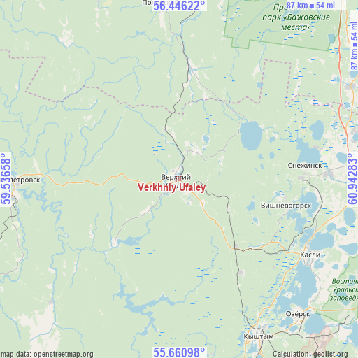
| Upper-left | 56.44622°, | 59.53658° |
| Center: | 56.0556°, | 60.2397° |
| Lower-right: | 55.66098°, | 60.94283° |
| Map W x H: | 87.3×87.3 km | = 54.2×54.2mi |
| max Lat: | 73.50819° ⇑32.6% North |
| Verkhniy Ufaley: | 56.0556° |
| min Lat: | ⇓67.4% South 41.28413° |
| min Long | Verkhniy Ufaley | max Long |
| -179.12198° | 60.2397° | 179.35046° |
| W 72.1%⇐ | ⇒27.9% E |
Elevation
Elevation of Verkhniy Ufaley is 375 m = 1230 ft, and this is 172.4 m = 566 ft above average elevation for this country.
| Max E: |
2518 m = 8261 ft | 12.8% |
| Verkhniy Ufaley | 375 m 1230 ft | |
| Avg. | 202.6 m = 665 ft | |
Min E: |
-28 m = -92 ft | 87.2% |
See also: Russia elevation on elevation.city.
Geographical zone
Verkhniy Ufaley is located in North temperate zone (between Tropic of Cancer and the Arctic Circle). Distance of this North polar circle is 1168.4 km =726 mi to North.| Distance of | km | miles | from Verkhniy Ufaley |
|---|---|---|---|
| North Pole | 3774.3 | 2345.2 | to North |
| Arctic Circle | 1168.4 | 726 | to North |
| Tropic Cancer | 3626.9 | 2253.7 | to South |
| Equator | 6232.8 | 3872.9 | to South |


Nearby cities:
15 places around Verkhniy Ufaley: (largest is in red/bold)
• Cheremshanka
7.3 km =4.5 mi,  13°
13°
• Kasli
37.3 km =23.2 mi,  119°
119°
• Kyshtym
42.7 km =26.5 mi,  152°
152°
• Nizhniy Ufaley
22.3 km =13.9 mi,  225°
225°
• Novogornyy
58.5 km =36.4 mi,  143°
143°
• Nyazepetrovsk
39.5 km =24.5 mi,  269°
269°
• Ozersk
44.1 km =27.4 mi, 139°
• Polevskoy
43.1 km =26.8 mi,  355°
355°
• Shchelkun
51.8 km =32.2 mi,  57°
57°
• Snezhinsk
30.7 km =19.1 mi,  83°
83°
• Tayginka
50.8 km =31.6 mi,  160°
160°
• Tyubuk
43.5 km =27 mi,  90°
90°
• Verkhnyaya Sysert’
53.3 km =33.1 mi,  36°
36°
• Vishnëvogorsk
27 km =16.8 mi,  105°
105°
• Zyuzel’skiy
48.3 km =30 mi,  352°
352°
Sources, notices
• [Note1] Compared only with cities in Russia existing in our database
• [Src1] Map data: © OpenStreetMap contributors (CC-BY-SA)
• [Src2] Other city data from geonames.org with taken over terms of usage.
• [Src3] Geographical zone / Annual Mean Temperature by Robert A. Rohde @ Wikipedia
