Vishnëvogorsk geodata
Vishnëvogorsk (Chelyabinsk) is a populated place; located in Russia in Asia/Yekaterinburg (GMT+5) time zone. With population of 5,800 people, there are 2331 cities with bigger population in this country. Compared to other cities in Russia, 66.5% of cities are located further ↓South; 72.8% of cities are located further ←West and 83.1% of cities have lower elevation than Vishnëvogorsk. Note1


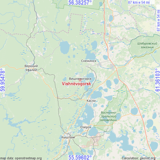
Vishnëvogorsk GPS coordinates[2]
55° 59' 28.68" North, 60° 39' 28.44" East
| Map corner | latitude | longitude |
|---|---|---|
| Upper-left | 56.38257°, | 59.95478° |
| Center: | 55.9913°, | 60.6579° |
| Lower-right: | 55.59602°, | 61.36103° |
| Map W x H: | 87.5×87.5 km | = 54.4×54.4mi |
| max Lat: | 73.50819° ⇑33.5% North |
| Vishnëvogorsk: | 55.9913° |
| min Lat: | ⇓66.5% South 41.28413° |
| min Long | Vishnëvogorsk | max Long |
| -179.12198° | 60.6579° | 179.35046° |
| W 72.8%⇐ | ⇒27.2% E |
Elevation
Elevation of Vishnëvogorsk is 288 m = 945 ft, and this is 85.4 m = 280 ft above average elevation for this country.
| Max E: |
2518 m = 8261 ft | 16.9% |
| Vishnëvogorsk | 288 m 945 ft | |
| Avg. | 202.6 m = 665 ft | |
Min E: |
-28 m = -92 ft | 83.1% |
See also: Russia elevation on elevation.city.
Geographical zone
Vishnëvogorsk is located in North temperate zone (between Tropic of Cancer and the Arctic Circle). Distance of this North polar circle is 1175.5 km =730.4 mi to North.| Distance of | km | miles | from Vishnëvogorsk |
|---|---|---|---|
| North Pole | 3781.4 | 2349.7 | to North |
| Arctic Circle | 1175.5 | 730.4 | to North |
| Tropic Cancer | 3619.7 | 2249.2 | to South |
| Equator | 6225.6 | 3868.4 | to South |


Nearby cities:
15 places around Vishnëvogorsk: (largest is in red/bold)
• Argayash
57.5 km =35.7 mi,  166°
166°
• Cheremshanka
28.1 km =17.5 mi,  300°
300°
• Kasli
12.9 km =8 mi,  149°
149°
• Kyshtym
31.5 km =19.6 mi,  192°
192°
• Nizhniy Ufaley
42.8 km =26.6 mi,  258°
258°
• Novogornyy
41 km =25.5 mi, 168°
• Ozersk
26.4 km =16.4 mi, 173°
• Shchelkun
39.1 km =24.3 mi,  27°
27°
• Snezhinsk
11.4 km =7.1 mi,  23°
23°
• Sysert’
57.7 km =35.9 mi,  9°
9°
• Tayginka
41.9 km =26 mi, 192°
• Tyubuk
18.9 km =11.7 mi,  67°
67°
• Uvil’dy
51.7 km =32.1 mi, 185°
• Verkhniy Ufaley
27 km =16.8 mi,  285°
285°
• Verkhnyaya Sysert’
50.3 km =31.3 mi, 6°
Sources, notices
• [Note1] Compared only with cities in Russia existing in our database
• [Src1] Map data: © OpenStreetMap contributors (CC-BY-SA)
• [Src2] Other city data from geonames.org with taken over terms of usage.
• [Src3] Geographical zone / Annual Mean Temperature by Robert A. Rohde @ Wikipedia
