Tsementnyy geodata
Tsementnyy (Sverdlovsk) is a populated place; located in Russia in Asia/Yekaterinburg (GMT+5) time zone. With population of 5,972 people, there are 2264 cities with bigger population in this country. Compared to other cities in Russia, 79.9% of cities are located further ↓South; 71.9% of cities are located further ←West and 80.9% of cities have lower elevation than Tsementnyy. Note1


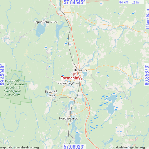
Tsementnyy GPS coordinates[2]
57° 28' 9.48" North, 60° 9' 12.96" East
| Map corner | latitude | longitude |
|---|---|---|
| Upper-left | 57.84545°, | 59.45048° |
| Center: | 57.4693°, | 60.1536° |
| Lower-right: | 57.08923°, | 60.85673° |
| Map W x H: | 84.1×84.1 km | = 52.3×52.3mi |
| max Lat: | 73.50819° ⇑20.1% North |
| Tsementnyy: | 57.4693° |
| min Lat: | ⇓79.9% South 41.28413° |
| min Long | Tsementnyy | max Long |
| -179.12198° | 60.1536° | 179.35046° |
| W 71.9%⇐ | ⇒28.1% E |
Elevation
Elevation of Tsementnyy is 257 m = 843 ft, and this is 54.4 m = 178 ft above average elevation for this country.
| Max E: |
2518 m = 8261 ft | 19.1% |
| Tsementnyy | 257 m 843 ft | |
| Avg. | 202.6 m = 665 ft | |
Min E: |
-28 m = -92 ft | 80.9% |
See also: Russia elevation on elevation.city.
Geographical zone
Tsementnyy is located in North temperate zone (between Tropic of Cancer and the Arctic Circle). Distance of this North polar circle is 1011.2 km =628.3 mi to North.| Distance of | km | miles | from Tsementnyy |
|---|---|---|---|
| North Pole | 3617.1 | 2247.6 | to North |
| Arctic Circle | 1011.2 | 628.3 | to North |
| Tropic Cancer | 3784.1 | 2351.3 | to South |
| Equator | 6390 | 3970.6 | to South |


Nearby cities:
15 places around Tsementnyy: (largest is in red/bold)
• Chernoistochinsk
34.1 km =21.2 mi,  330°
330°
• Kalinovo
37.5 km =23.3 mi,  180°
180°
• Karpushikha
15.8 km =9.8 mi,  283°
283°
• Kirovgrad
7.1 km =4.4 mi,  231°
231°
• Levikha
19.8 km =12.3 mi,  310°
310°
• Nev’yansk
4.5 km =2.8 mi,  49°
49°
• Neyvo-Rudyanka
13.9 km =8.6 mi, 184°
• Nikolo-Pavlovskoye
35.4 km =22 mi,  350°
350°
• Novoasbest
31.4 km =19.5 mi,  14°
14°
• Novoural’sk
25.4 km =15.8 mi,  189°
189°
• Petrokamenskoye
40.3 km =25 mi, 47°
• Tavatuy
35.5 km =22.1 mi,  174°
174°
• Uralets
36.9 km =22.9 mi, 305°
• Verkh-Neyvinskiy
22.2 km =13.8 mi, 182°
• Verkhniy Tagil
16 km =9.9 mi, 227°
Sources, notices
• [Note1] Compared only with cities in Russia existing in our database
• [Src1] Map data: © OpenStreetMap contributors (CC-BY-SA)
• [Src2] Other city data from geonames.org with taken over terms of usage.
• [Src3] Geographical zone / Annual Mean Temperature by Robert A. Rohde @ Wikipedia
