Tobol’sk geodata
Tobol’sk (Tyumen’ Oblast) is a populated place; located in Russia in Asia/Yekaterinburg (GMT+5) time zone. With population of 113,800 people, there are 178 cities with bigger population in this country. Compared to other cities in Russia, 83.5% of cities are located further ↓South; 76.8% of cities are located further ←West and 74.4% of cities have higher elevation than Tobol’sk. Note1


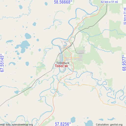
Tobol’sk GPS coordinates[2]
58° 11' 53.052" North, 68° 15' 16.452" East
| Map corner | latitude | longitude |
|---|---|---|
| Upper-left | 58.56668°, | 67.55145° |
| Center: | 58.19807°, | 68.25457° |
| Lower-right: | 57.8256°, | 68.9577° |
| Map W x H: | 82.4×82.4 km | = 51.2×51.2mi |
| max Lat: | 73.50819° ⇑16.5% North |
| Tobol’sk: | 58.19807° |
| min Lat: | ⇓83.5% South 41.28413° |
| min Long | Tobol’sk | max Long |
| -179.12198° | 68.25457° | 179.35046° |
| W 76.8%⇐ | ⇒23.2% E |
Elevation
Elevation of Tobol’sk is 90 m = 295 ft, and this is 112.6 m = 369 ft below average elevation for this country.
| Max E: |
2518 m = 8261 ft | 74.4% |
| Avg. | 202.6 m = 665 ft | |
| Tobol’sk | 90 m = 295 ft | |
Min E: |
-28 m = -92 ft | 25.6% |
See also: Tobol’sk elevation on elevation.city.
Geographical zone
Tobol’sk is located in North temperate zone (between Tropic of Cancer and the Arctic Circle). Distance of this North polar circle is 930.2 km =578 mi to North.| Distance of | km | miles | from Tobol’sk |
|---|---|---|---|
| North Pole | 3536 | 2197.2 | to North |
| Arctic Circle | 930.2 | 578 | to North |
| Tropic Cancer | 3865.1 | 2401.7 | to South |
| Equator | 6471 | 4020.9 | to South |


Nearby cities:
15 places around Tobol’sk: (largest is in red/bold)
• Abalak
21.4 km =13.3 mi,  111°
111°
• Aromashevo
150.5 km =93.5 mi,  171°
171°
• Irtyshskiy
16.6 km =10.3 mi,  334°
334°
• Kondinskoye
168.3 km =104.6 mi,  343°
343°
• Kuminskiy
111.2 km =69.1 mi,  297°
297°
• Mendeleyevo
4.4 km =2.7 mi,  142°
142°
• Nizhnyaya Tavda
136.1 km =84.6 mi,  244°
244°
• Sumkino
10.5 km =6.5 mi,  157°
157°
• Tavda
175.9 km =109.3 mi,  264°
264°
• Turtas
96.9 km =60.2 mi,  31°
31°
• Uspenka
165.8 km =103 mi, 159°
• Uvat
111.2 km =69.1 mi,  19°
19°
• Vagay
53.6 km =33.3 mi,  122°
122°
• Yarkovo
113 km =70.2 mi,  218°
218°
• Yurginskoye
161.8 km =100.5 mi,  198°
198°
Sources, notices
• [Note1] Compared only with cities in Russia existing in our database
• [Src1] Map data: © OpenStreetMap contributors (CC-BY-SA)
• [Src2] Other city data from geonames.org with taken over terms of usage.
• [Src3] Geographical zone / Annual Mean Temperature by Robert A. Rohde @ Wikipedia
