Turtas geodata
Turtas (Tyumen’ Oblast) is a populated place; located in Russia in Asia/Yekaterinburg (GMT+5) time zone. With population of 5,050 people, there are 2639 cities with bigger population in this country. Compared to other cities in Russia, 86.3% of cities are located further ↓South; 77% of cities are located further ←West and 82.4% of cities have higher elevation than Turtas. Note1


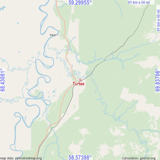
Turtas GPS coordinates[2]
58° 56' 19.212" North, 69° 8' 2.148" East
| Map corner | latitude | longitude |
|---|---|---|
| Upper-left | 59.29955°, | 68.43081° |
| Center: | 58.93867°, | 69.13393° |
| Lower-right: | 58.57398°, | 69.83706° |
| Map W x H: | 80.7×80.7 km | = 50.1×50.1mi |
| max Lat: | 73.50819° ⇑13.7% North |
| Turtas: | 58.93867° |
| min Lat: | ⇓86.3% South 41.28413° |
| min Long | Turtas | max Long |
| -179.12198° | 69.13393° | 179.35046° |
| W 77%⇐ | ⇒23% E |
Elevation
Elevation of Turtas is 61 m = 200 ft, and this is 141.6 m = 465 ft below average elevation for this country.
| Max E: |
2518 m = 8261 ft | 82.4% |
| Avg. | 202.6 m = 665 ft | |
| Turtas | 61 m = 200 ft | |
Min E: |
-28 m = -92 ft | 17.6% |
See also: Russia elevation on elevation.city.
Geographical zone
Turtas is located in North temperate zone (between Tropic of Cancer and the Arctic Circle). Distance of this North polar circle is 847.8 km =526.8 mi to North.| Distance of | km | miles | from Turtas |
|---|---|---|---|
| North Pole | 3453.7 | 2146 | to North |
| Arctic Circle | 847.8 | 526.8 | to North |
| Tropic Cancer | 3947.4 | 2452.8 | to South |
| Equator | 6553.4 | 4072.1 | to South |


Nearby cities:
15 places around Turtas: (largest is in red/bold)
• Abalak
95.4 km =59.3 mi,  199°
199°
• Gornopravdinsk
130.9 km =81.3 mi,  19°
19°
• Irtyshskiy
88.8 km =55.2 mi,  220°
220°
• Kondinskoye
125.7 km =78.1 mi,  308°
308°
• Kuminskiy
150.9 km =93.8 mi,  258°
258°
• Mendeleyevo
98.5 km =61.2 mi,  209°
209°
• Mezhdurechenskiy
196.1 km =121.9 mi,  292°
292°
• Mortka
182.8 km =113.6 mi,  283°
283°
• Salym
182 km =113.1 mi,  46°
46°
• Sumkino
103.3 km =64.2 mi, 207°
• Tobol’sk
96.9 km =60.2 mi, 211°
• Ust’-Ishim
182.4 km =113.3 mi,  139°
139°
• Uvat
26.6 km =16.5 mi,  328°
328°
• Vagay
111.7 km =69.4 mi,  183°
183°
• Yarkovo
209.4 km =130.1 mi, 215°
Sources, notices
• [Note1] Compared only with cities in Russia existing in our database
• [Src1] Map data: © OpenStreetMap contributors (CC-BY-SA)
• [Src2] Other city data from geonames.org with taken over terms of usage.
• [Src3] Geographical zone / Annual Mean Temperature by Robert A. Rohde @ Wikipedia
