Baraba geodata
Baraba (Sverdlovsk) is a populated place; located in Russia in Asia/Yekaterinburg (GMT+5) time zone. With population of 1,153 people, there are 4550 cities with bigger population in this country. Compared to other cities in Russia, 74.8% of cities are located further ↓South; 74.3% of cities are located further ←West and 73.5% of cities have lower elevation than Baraba. Note1


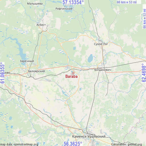
Baraba GPS coordinates[2]
56° 45' 0" North, 61° 46' 0.012" East
| Map corner | latitude | longitude |
|---|---|---|
| Upper-left | 57.13354°, | 61.06355° |
| Center: | 56.75°, | 61.76667° |
| Lower-right: | 56.3625°, | 62.4698° |
| Map W x H: | 85.7×85.7 km | = 53.3×53.3mi |
| max Lat: | 73.50819° ⇑25.2% North |
| Baraba: | 56.75° |
| min Lat: | ⇓74.8% South 41.28413° |
| min Long | Baraba | max Long |
| -179.12198° | 61.76667° | 179.35046° |
| W 74.3%⇐ | ⇒25.7% E |
Elevation
Elevation of Baraba is 210 m = 689 ft, and this is 7.4 m = 24 ft above average elevation for this country.
| Max E: |
2518 m = 8261 ft | 26.5% |
| Baraba | 210 m 689 ft | |
| Avg. | 202.6 m = 665 ft | |
Min E: |
-28 m = -92 ft | 73.5% |
See also: Russia elevation on elevation.city.
Geographical zone
Baraba is located in North temperate zone (between Tropic of Cancer and the Arctic Circle). Distance of this North polar circle is 1091.2 km =678 mi to North.| Distance of | km | miles | from Baraba |
|---|---|---|---|
| North Pole | 3697.1 | 2297.3 | to North |
| Arctic Circle | 1091.2 | 678 | to North |
| Tropic Cancer | 3704.1 | 2301.6 | to South |
| Equator | 6310 | 3920.9 | to South |


Nearby cities:
15 places around Baraba: (largest is in red/bold)
• Asbest
34.5 km =21.4 mi,  327°
327°
• Beloyarskiy
21.5 km =13.4 mi,  272°
272°
• Bogdanovich
17.6 km =10.9 mi,  78°
78°
• Dvurechensk
44.3 km =27.5 mi,  247°
247°
• Gryaznovskoye
5.2 km =3.2 mi,  314°
314°
• Izumrud
42.8 km =26.6 mi, 328°
• Kamensk-Ural’skiy
38.2 km =23.7 mi,  164°
164°
• Martyush
39.6 km =24.6 mi,  169°
169°
• Pokrovskoye
32.5 km =20.2 mi,  197°
197°
• Reftinskiy
38.2 km =23.7 mi,  351°
351°
• Sarapulka
45.2 km =28.1 mi,  286°
286°
• Sovkhoznyy
29.7 km =18.5 mi,  224°
224°
• Sukhoy Log
23.9 km =14.9 mi,  42°
42°
• Verkhneye Dubrovo
43.9 km =27.3 mi, 270°
• Zarechnyy
27.7 km =17.2 mi,  284°
284°
Sources, notices
• [Note1] Compared only with cities in Russia existing in our database
• [Src1] Map data: © OpenStreetMap contributors (CC-BY-SA)
• [Src2] Other city data from geonames.org with taken over terms of usage.
• [Src3] Geographical zone / Annual Mean Temperature by Robert A. Rohde @ Wikipedia
