Gorno-Altaysk geodata
Gorno-Altaysk (Altai) is a seat of a first-order administrative division; located in Russia in Asia/Barnaul (GMT+7) time zone. With population of 54,917 people, there are 385 cities with bigger population in this country. Compared to other cities in Russia, 69.4% of cities are located further ↑North; 83.4% of cities are located further ←West and 83% of cities have lower elevation than Gorno-Altaysk. Note1


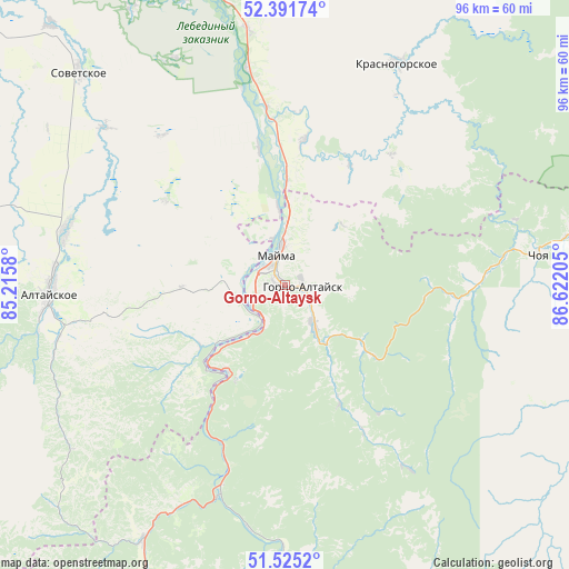
Gorno-Altaysk GPS coordinates[2]
51° 57' 38.016" North, 85° 55' 8.112" East
| Map corner | latitude | longitude |
|---|---|---|
| Upper-left | 52.39174°, | 85.2158° |
| Center: | 51.96056°, | 85.91892° |
| Lower-right: | 51.5252°, | 86.62205° |
| Map W x H: | 96.4×96.3 km | = 59.9×59.8mi |
| max Lat: | 73.50819° ⇑69.4% North |
| Gorno-Altaysk: | 51.96056° |
| min Lat: | ⇓30.6% South 41.28413° |
| min Long | Gorno-Altaysk | max Long |
| -179.12198° | 85.91892° | 179.35046° |
| W 83.4%⇐ | ⇒16.6% E |
Elevation
Elevation of Gorno-Altaysk is 285 m = 935 ft, and this is 82.4 m = 270 ft above average elevation for this country.
| Max E: |
2518 m = 8261 ft | 17% |
| Gorno-Altaysk | 285 m 935 ft | |
| Avg. | 202.6 m = 665 ft | |
Min E: |
-28 m = -92 ft | 83% |
See also: Gorno-Altaysk elevation on elevation.city.
Geographical zone
Gorno-Altaysk is located in North temperate zone (between Tropic of Cancer and the Arctic Circle). Distance of this North polar circle is 1623.7 km =1008.9 mi to North.| Distance of | km | miles | from Gorno-Altaysk |
|---|---|---|---|
| North Pole | 4229.6 | 2628.2 | to North |
| Arctic Circle | 1623.7 | 1008.9 | to North |
| Tropic Cancer | 3171.6 | 1970.7 | to South |
| Equator | 5777.5 | 3590 | to South |


Nearby cities:
15 places around Gorno-Altaysk: (largest is in red/bold)
• Altayskoye
40.2 km =25 mi,  268°
268°
• Aya
8.2 km =5.1 mi,  258°
258°
• Bystryanka
36.7 km =22.8 mi,  350°
350°
• Choya
43.3 km =26.9 mi,  82°
82°
• Kamlak
41.5 km =25.8 mi,  205°
205°
• Krasnogorskoye
41.8 km =26 mi,  27°
27°
• Manzherok
17.5 km =10.9 mi, 214°
• Mayma
6.2 km =3.9 mi, 354°
• Platovo
13.3 km =8.3 mi,  355°
355°
• Sarasa
39.7 km =24.7 mi, 256°
• Setovka
40.5 km =25.2 mi,  311°
311°
• Shul’gin Log
23.7 km =14.7 mi, 349°
• Souzga
9.4 km =5.8 mi, 210°
• Ust’-Isha
24.8 km =15.4 mi,  7°
7°
• Половинка
35.8 km =22.2 mi,  315°
315°
Sources, notices
• [Note1] Compared only with cities in Russia existing in our database
• [Src1] Map data: © OpenStreetMap contributors (CC-BY-SA)
• [Src2] Other city data from geonames.org with taken over terms of usage.
• [Src3] Geographical zone / Annual Mean Temperature by Robert A. Rohde @ Wikipedia
