Manzherok geodata
Manzherok (Altai) is a populated place; located in Russia in Asia/Barnaul (GMT+7) time zone. With population of 1,700 people, there are 4290 cities with bigger population in this country. Compared to other cities in Russia, 70.3% of cities are located further ↑North; 83.1% of cities are located further ←West and 82.8% of cities have lower elevation than Manzherok. Note1


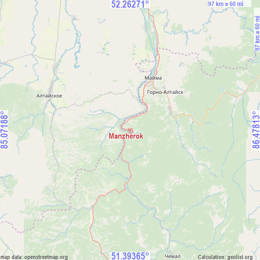
Manzherok GPS coordinates[2]
51° 49' 49.008" North, 85° 46' 30" East
| Map corner | latitude | longitude |
|---|---|---|
| Upper-left | 52.26271°, | 85.07188° |
| Center: | 51.83028°, | 85.775° |
| Lower-right: | 51.39365°, | 86.47813° |
| Map W x H: | 96.6×96.6 km | = 60×60mi |
| max Lat: | 73.50819° ⇑70.3% North |
| Manzherok: | 51.83028° |
| min Lat: | ⇓29.7% South 41.28413° |
| min Long | Manzherok | max Long |
| -179.12198° | 85.775° | 179.35046° |
| W 83.1%⇐ | ⇒16.9% E |
Elevation
Elevation of Manzherok is 282 m = 925 ft, and this is 79.4 m = 260 ft above average elevation for this country.
| Max E: |
2518 m = 8261 ft | 17.2% |
| Manzherok | 282 m 925 ft | |
| Avg. | 202.6 m = 665 ft | |
Min E: |
-28 m = -92 ft | 82.8% |
See also: Russia elevation on elevation.city.
Geographical zone
Manzherok is located in North temperate zone (between Tropic of Cancer and the Arctic Circle). Distance of this North polar circle is 1638.2 km =1017.9 mi to North.| Distance of | km | miles | from Manzherok |
|---|---|---|---|
| North Pole | 4244.1 | 2637.2 | to North |
| Arctic Circle | 1638.2 | 1017.9 | to North |
| Tropic Cancer | 3157.1 | 1961.7 | to South |
| Equator | 5763 | 3581 | to South |


Nearby cities:
15 places around Manzherok: (largest is in red/bold)
• Altayskoye
33.3 km =20.7 mi,  294°
294°
• Aya
12.9 km =8 mi,  8°
8°
• Cherga
32.5 km =20.2 mi,  206°
206°
• Elekmonar
43.8 km =27.2 mi,  160°
160°
• Gorno-Altaysk
17.5 km =10.9 mi,  34°
34°
• Kamlak
24.3 km =15.1 mi,  198°
198°
• Mayma
22.6 km =14 mi,  24°
24°
• Platovo
29.1 km =18.1 mi, 17°
• Sarasa
29.2 km =18.1 mi,  280°
280°
• Setovka
46.1 km =28.6 mi,  333°
333°
• Shul’gin Log
38.2 km =23.7 mi, 8°
• Souzga
8.1 km =5 mi,  38°
38°
• Ust’-Isha
41.3 km =25.7 mi, 18°
• Uznezya
35.6 km =22.1 mi, 161°
• Половинка
43 km =26.7 mi,  339°
339°
Sources, notices
• [Note1] Compared only with cities in Russia existing in our database
• [Src1] Map data: © OpenStreetMap contributors (CC-BY-SA)
• [Src2] Other city data from geonames.org with taken over terms of usage.
• [Src3] Geographical zone / Annual Mean Temperature by Robert A. Rohde @ Wikipedia
