Beya geodata
Beya (Khakasiya Republic) is a populated place; located in Russia in Asia/Krasnoyarsk (GMT+7) time zone. With population of 5,338 people, there are 2493 cities with bigger population in this country. Compared to other cities in Russia, 62.5% of cities are located further ↑North; 86% of cities are located further ←West and 89.5% of cities have lower elevation than Beya. Note1


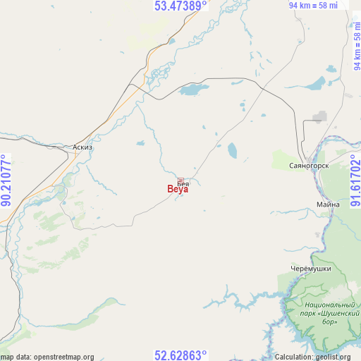
Beya GPS coordinates[2]
53° 3' 11.988" North, 90° 54' 50.004" East
| Map corner | latitude | longitude |
|---|---|---|
| Upper-left | 53.47389°, | 90.21077° |
| Center: | 53.05333°, | 90.91389° |
| Lower-right: | 52.62863°, | 91.61702° |
| Map W x H: | 94×94 km | = 58.4×58.4mi |
| max Lat: | 73.50819° ⇑62.5% North |
| Beya: | 53.05333° |
| min Lat: | ⇓37.5% South 41.28413° |
| min Long | Beya | max Long |
| -179.12198° | 90.91389° | 179.35046° |
| W 86%⇐ | ⇒14% E |
Elevation
Elevation of Beya is 442 m = 1450 ft, and this is 239.4 m = 785 ft above average elevation for this country.
| Max E: |
2518 m = 8261 ft | 10.5% |
| Beya | 442 m 1450 ft | |
| Avg. | 202.6 m = 665 ft | |
Min E: |
-28 m = -92 ft | 89.5% |
See also: Russia elevation on elevation.city.
Geographical zone
Beya is located in North temperate zone (between Tropic of Cancer and the Arctic Circle). Distance of this North polar circle is 1502.2 km =933.4 mi to North.| Distance of | km | miles | from Beya |
|---|---|---|---|
| North Pole | 4108.1 | 2552.7 | to North |
| Arctic Circle | 1502.2 | 933.4 | to North |
| Tropic Cancer | 3293.1 | 2046.2 | to South |
| Equator | 5899 | 3665.5 | to South |


Nearby cities:
15 places around Beya: (largest is in red/bold)
• Abakan
81.2 km =50.5 mi,  24°
24°
• Abaza
70.7 km =43.9 mi,  231°
231°
• Askiz
27.3 km =17 mi,  288°
288°
• Askiz
33.7 km =20.9 mi, 286°
• Belyy Yar
68.9 km =42.8 mi,  27°
27°
• Chernogorsk
89.1 km =55.4 mi, 15°
• Cherëmushki
40.2 km =25 mi,  123°
123°
• Il’ichevo
66.6 km =41.4 mi,  67°
67°
• Mayna
38.5 km =23.9 mi,  97°
97°
• Minusinsk
89.3 km =55.5 mi,  35°
35°
• Podsineye
79.7 km =49.5 mi, 31°
• Sayanogorsk
32.7 km =20.3 mi,  83°
83°
• Shushenskoye
74.5 km =46.3 mi, 66°
• Tashtyp
74.1 km =46 mi,  247°
247°
• Zelënyy Bor
78.5 km =48.8 mi, 36°
Sources, notices
• [Note1] Compared only with cities in Russia existing in our database
• [Src1] Map data: © OpenStreetMap contributors (CC-BY-SA)
• [Src2] Other city data from geonames.org with taken over terms of usage.
• [Src3] Geographical zone / Annual Mean Temperature by Robert A. Rohde @ Wikipedia
