Choya geodata
Choya (Altai) is a populated place; located in Russia in Asia/Barnaul (GMT+7) time zone. With population of 1,930 people, there are 4206 cities with bigger population in this country. Compared to other cities in Russia, 69.2% of cities are located further ↑North; 84.3% of cities are located further ←West and 83.4% of cities have lower elevation than Choya. Note1


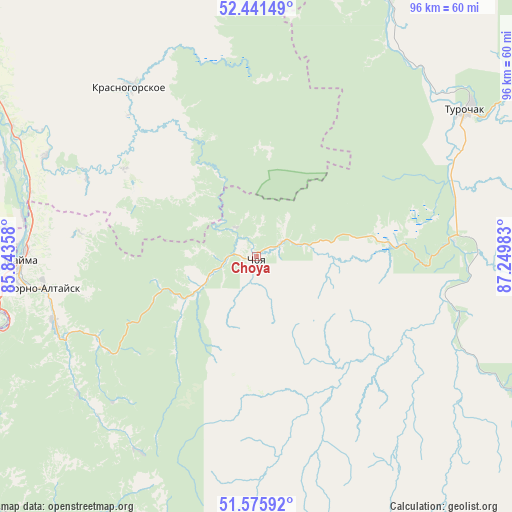
Choya GPS coordinates[2]
52° 0' 38.88" North, 86° 32' 48.12" East
| Map corner | latitude | longitude |
|---|---|---|
| Upper-left | 52.44149°, | 85.84358° |
| Center: | 52.0108°, | 86.5467° |
| Lower-right: | 51.57592°, | 87.24983° |
| Map W x H: | 96.2×96.2 km | = 59.8×59.8mi |
| max Lat: | 73.50819° ⇑69.2% North |
| Choya: | 52.0108° |
| min Lat: | ⇓30.8% South 41.28413° |
| min Long | Choya | max Long |
| -179.12198° | 86.5467° | 179.35046° |
| W 84.3%⇐ | ⇒15.7% E |
Elevation
Elevation of Choya is 292 m = 958 ft, and this is 89.4 m = 293 ft above average elevation for this country.
| Max E: |
2518 m = 8261 ft | 16.6% |
| Choya | 292 m 958 ft | |
| Avg. | 202.6 m = 665 ft | |
Min E: |
-28 m = -92 ft | 83.4% |
See also: Russia elevation on elevation.city.
Geographical zone
Choya is located in North temperate zone (between Tropic of Cancer and the Arctic Circle). Distance of this North polar circle is 1618.1 km =1005.4 mi to North.| Distance of | km | miles | from Choya |
|---|---|---|---|
| North Pole | 4224 | 2624.7 | to North |
| Arctic Circle | 1618.1 | 1005.4 | to North |
| Tropic Cancer | 3177.1 | 1974.2 | to South |
| Equator | 5783.1 | 3593.5 | to South |


Nearby cities:
15 places around Choya: (largest is in red/bold)
• Artybash
55.6 km =34.5 mi,  115°
115°
• Aya
51.5 km =32 mi,  261°
261°
• Berëzovka
62 km =38.5 mi,  307°
307°
• Bystryanka
57.8 km =35.9 mi,  301°
301°
• Dmitriyevka
54 km =33.6 mi,  27°
27°
• Gorno-Altaysk
43.3 km =26.9 mi, 262°
• Iogach
55.4 km =34.4 mi, 117°
• Krasnogorskoye
39.6 km =24.6 mi,  323°
323°
• Manzherok
56.6 km =35.2 mi,  249°
249°
• Mayma
43.6 km =27.1 mi,  270°
270°
• Platovo
44.7 km =27.8 mi,  279°
279°
• Shul’gin Log
50.4 km =31.3 mi,  290°
290°
• Souzga
49.7 km =30.9 mi, 253°
• Turochak
47.9 km =29.8 mi,  55°
55°
• Ust’-Isha
43.9 km =27.3 mi, 295°
Sources, notices
• [Note1] Compared only with cities in Russia existing in our database
• [Src1] Map data: © OpenStreetMap contributors (CC-BY-SA)
• [Src2] Other city data from geonames.org with taken over terms of usage.
• [Src3] Geographical zone / Annual Mean Temperature by Robert A. Rohde @ Wikipedia
