Bystryy Istok geodata
Bystryy Istok (Altai Krai) is a populated place; located in Russia in Asia/Barnaul (GMT+7) time zone. With population of 4,455 people, there are 2885 cities with bigger population in this country. Compared to other cities in Russia, 67% of cities are located further ↑North; 81.7% of cities are located further ←West and 54.5% of cities have lower elevation than Bystryy Istok. Note1


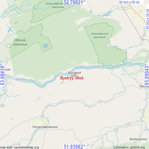
Bystryy Istok GPS coordinates[2]
52° 22' 15.6" North, 84° 23' 14.28" East
| Map corner | latitude | longitude |
|---|---|---|
| Upper-left | 52.79821°, | 83.68418° |
| Center: | 52.371°, | 84.3873° |
| Lower-right: | 51.93962°, | 85.09043° |
| Map W x H: | 95.5×95.5 km | = 59.3×59.3mi |
| max Lat: | 73.50819° ⇑67% North |
| Bystryy Istok: | 52.371° |
| min Lat: | ⇓33% South 41.28413° |
| min Long | Bystryy Istok | max Long |
| -179.12198° | 84.3873° | 179.35046° |
| W 81.7%⇐ | ⇒18.3% E |
Elevation
Elevation of Bystryy Istok is 155 m = 509 ft, and this is 47.6 m = 156 ft below average elevation for this country.
| Max E: |
2518 m = 8261 ft | 45.5% |
| Avg. | 202.6 m = 665 ft | |
| Bystryy Istok | 155 m = 509 ft | |
Min E: |
-28 m = -92 ft | 54.5% |
See also: Russia elevation on elevation.city.
Geographical zone
Bystryy Istok is located in North temperate zone (between Tropic of Cancer and the Arctic Circle). Distance of this North polar circle is 1578.1 km =980.6 mi to North.| Distance of | km | miles | from Bystryy Istok |
|---|---|---|---|
| North Pole | 4184 | 2599.8 | to North |
| Arctic Circle | 1578.1 | 980.6 | to North |
| Tropic Cancer | 3217.2 | 1999.1 | to South |
| Equator | 5823.1 | 3618.3 | to South |


Nearby cities:
15 places around Bystryy Istok: (largest is in red/bold)
• Anton’yevka
50.3 km =31.3 mi,  214°
214°
• Belokurikha
58.5 km =36.4 mi,  135°
135°
• Biysk
58.5 km =36.4 mi,  71°
71°
• Nikolayevka
26.6 km =16.5 mi,  221°
221°
• Novopokrovka
16.9 km =10.5 mi,  168°
168°
• Novotyryshkino
47.8 km =29.7 mi,  132°
132°
• Pautovo
19 km =11.8 mi, 205°
• Petropavlovskoye
38.4 km =23.9 mi, 209°
• Shubenka
57.6 km =35.8 mi,  56°
56°
• Smolenskoye
47.5 km =29.5 mi,  98°
98°
• Sokolovo
32.6 km =20.3 mi, 56°
• Sychëvka
44.5 km =27.7 mi, 143°
• Ust’-Charyshskaya Pristan’
49.2 km =30.6 mi,  272°
272°
• Verkh-Obskiy
43.1 km =26.8 mi,  83°
83°
• Zonal’noye
49.4 km =30.7 mi,  48°
48°
Sources, notices
• [Note1] Compared only with cities in Russia existing in our database
• [Src1] Map data: © OpenStreetMap contributors (CC-BY-SA)
• [Src2] Other city data from geonames.org with taken over terms of usage.
• [Src3] Geographical zone / Annual Mean Temperature by Robert A. Rohde @ Wikipedia
