Petropavlovskoye geodata
Petropavlovskoye (Altai Krai) is a populated place; located in Russia in Asia/Barnaul (GMT+7) time zone. With population of 2,839 people, there are 3848 cities with bigger population in this country. Compared to other cities in Russia, 68.8% of cities are located further ↑North; 81.6% of cities are located further ←West and 72.2% of cities have lower elevation than Petropavlovskoye. Note1


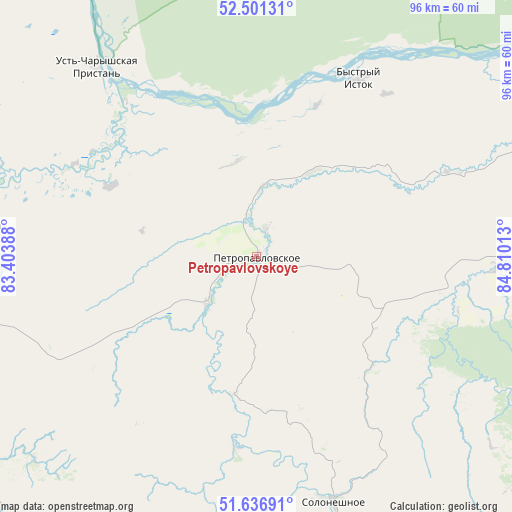
Petropavlovskoye GPS coordinates[2]
52° 4' 16.32" North, 84° 6' 25.2" East
| Map corner | latitude | longitude |
|---|---|---|
| Upper-left | 52.50131°, | 83.40388° |
| Center: | 52.0712°, | 84.107° |
| Lower-right: | 51.63691°, | 84.81013° |
| Map W x H: | 96.1×96.1 km | = 59.7×59.7mi |
| max Lat: | 73.50819° ⇑68.8% North |
| Petropavlovskoye: | 52.0712° |
| min Lat: | ⇓31.2% South 41.28413° |
| min Long | Petropavlovskoy | max Long |
| -179.12198° | 84.107° | 179.35046° |
| W 81.6%⇐ | ⇒18.4% E |
Elevation
Elevation of Petropavlovskoye is 205 m = 673 ft, and this is 2.4 m = 8 ft above average elevation for this country.
| Max E: |
2518 m = 8261 ft | 27.8% |
| Petropavlovskoye | 205 m 673 ft | |
| Avg. | 202.6 m = 665 ft | |
Min E: |
-28 m = -92 ft | 72.2% |
See also: Russia elevation on elevation.city.
Geographical zone
Petropavlovskoye is located in North temperate zone (between Tropic of Cancer and the Arctic Circle). Distance of this North polar circle is 1611.4 km =1001.3 mi to North.| Distance of | km | miles | from Petropavlovskoye |
|---|---|---|---|
| North Pole | 4217.3 | 2620.5 | to North |
| Arctic Circle | 1611.4 | 1001.3 | to North |
| Tropic Cancer | 3183.9 | 1978.4 | to South |
| Equator | 5789.8 | 3597.6 | to South |


Nearby cities:
15 places around Petropavlovskoye: (largest is in red/bold)
• Anton’yevka
12.3 km =7.6 mi,  227°
227°
• Belokurikha
61 km =37.9 mi,  97°
97°
• Bystryy Istok
38.4 km =23.9 mi,  29°
29°
• Nikolayevka
13.5 km =8.4 mi,  5°
5°
• Novopokrovka
28 km =17.4 mi,  53°
53°
• Novotyryshkino
54.8 km =34.1 mi,  88°
88°
• Pautovo
19.6 km =12.2 mi, 34°
• Smolenskoye
71.1 km =44.2 mi,  68°
68°
• Sokolovo
69.1 km =42.9 mi,  42°
42°
• Soloneshnoye
48.6 km =30.2 mi,  162°
162°
• Starobelokurikha
67.1 km =41.7 mi, 91°
• Sychëvka
46 km =28.6 mi, 92°
• Topol’noye
67.4 km =41.9 mi, 157°
• Ust’-Charyshskaya Pristan’
46.9 km =29.1 mi,  319°
319°
• Ust’-Kalmanka
55.1 km =34.2 mi,  275°
275°
Sources, notices
• [Note1] Compared only with cities in Russia existing in our database
• [Src1] Map data: © OpenStreetMap contributors (CC-BY-SA)
• [Src2] Other city data from geonames.org with taken over terms of usage.
• [Src3] Geographical zone / Annual Mean Temperature by Robert A. Rohde @ Wikipedia
