Ust’-Charyshskaya Pristan’ geodata
Ust’-Charyshskaya Pristan’ (Altai Krai) is a populated place; located in Russia in Asia/Barnaul (GMT+7) time zone. With population of 5,647 people, there are 2381 cities with bigger population in this country. Compared to other cities in Russia, 66.9% of cities are located further ↑North; 81.1% of cities are located further ←West and 64.3% of cities have lower elevation than Ust’-Charyshskaya Pristan’. Note1
Current local time in Ust’-Charyshskaya Pristan’:
10:03 PM, MondayDifference from your time zone: hours


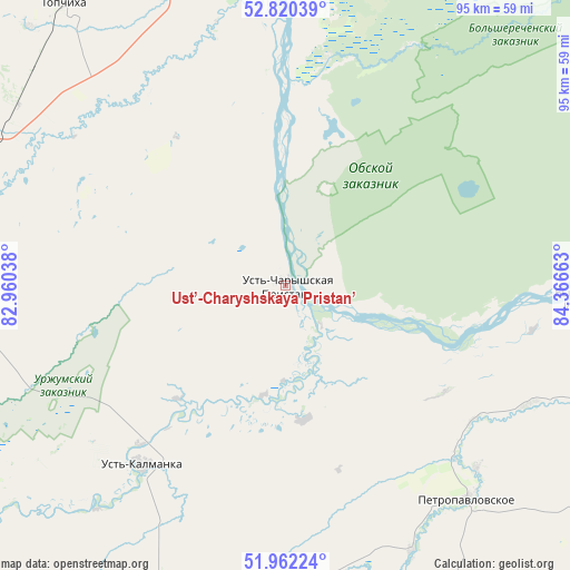
Ust’-Charyshskaya Pristan’ GPS coordinates[2]
52° 23' 36.24" North, 83° 39' 48.6" East
| Map corner | latitude | longitude |
|---|---|---|
| Upper-left | 52.82039°, | 82.96038° |
| Center: | 52.3934°, | 83.6635° |
| Lower-right: | 51.96224°, | 84.36663° |
| Map W x H: | 95.4×95.4 km | = 59.3×59.3mi |
| max Lat: | 73.50819° ⇑66.9% North |
| Ust’-Charyshskaya Pristan’: | 52.3934° |
| min Lat: | ⇓33.1% South 41.28413° |
| min Long | Ust’-Charyshs | max Long |
| -179.12198° | 83.6635° | 179.35046° |
| W 81.1%⇐ | ⇒18.9% E |
Elevation
Elevation of Ust’-Charyshskaya Pristan’ is 180 m = 591 ft, and this is 22.6 m = 74 ft below average elevation for this country.
| Max E: |
2518 m = 8261 ft | 35.7% |
| Avg. | 202.6 m = 665 ft | |
| Ust’-Charyshskaya Pristan’ | 180 m = 591 ft | |
Min E: |
-28 m = -92 ft | 64.3% |
See also: Russia elevation on elevation.city.
Geographical zone
Ust’-Charyshskaya Pristan’ is located in North temperate zone (between Tropic of Cancer and the Arctic Circle). Distance of this North polar circle is 1575.6 km =979 mi to North.| Distance of | km | miles | from Ust’-Charyshskaya Pristan’ |
|---|---|---|---|
| North Pole | 4181.5 | 2598.3 | to North |
| Arctic Circle | 1575.6 | 979 | to North |
| Tropic Cancer | 3219.7 | 2000.6 | to South |
| Equator | 5825.6 | 3619.9 | to South |


Nearby cities:
15 places around Ust’-Charyshskaya Pristan’: (largest is in red/bold)
• Aleysk
60.7 km =37.7 mi,  280°
280°
• Anton’yevka
49 km =30.4 mi,  154°
154°
• Bobrovka
89 km =55.3 mi,  9°
9°
• Bystryy Istok
49.2 km =30.6 mi,  92°
92°
• Chernitsk
90.9 km =56.5 mi,  355°
355°
• Kalmanka
56.8 km =35.3 mi,  351°
351°
• Nagornyy
45.4 km =28.2 mi, 350°
• Nikolayevka
38.7 km =24 mi,  125°
125°
• Novopokrovka
55.8 km =34.7 mi,  109°
109°
• Pautovo
45.6 km =28.3 mi,  115°
115°
• Petropavlovskoye
46.9 km =29.1 mi,  139°
139°
• Sokolovo
77.8 km =48.3 mi,  78°
78°
• Sychëvka
85 km =52.8 mi, 116°
• Topchikha
60 km =37.3 mi,  322°
322°
• Ust’-Kalmanka
38.9 km =24.2 mi,  218°
218°
Sources, notices
• [Note1] Compared only with cities in Russia existing in our database
• [Src1] Map data: © OpenStreetMap contributors (CC-BY-SA)
• [Src2] Other city data from geonames.org with taken over terms of usage.
• [Src3] Geographical zone / Annual Mean Temperature by Robert A. Rohde @ Wikipedia
