Svobodnyy geodata
Svobodnyy (Sverdlovsk) is a populated place; located in Russia in Asia/Yekaterinburg (GMT+5) time zone. With population of 9,508 people, there are 1591 cities with bigger population in this country. Compared to other cities in Russia, 82.8% of cities are located further ↓South; 72.3% of cities are located further ←West and 76.4% of cities have lower elevation than Svobodnyy. Note1


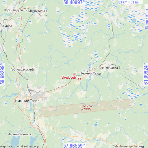
Svobodnyy GPS coordinates[2]
58° 2' 22.992" North, 60° 23' 45.996" East
| Map corner | latitude | longitude |
|---|---|---|
| Upper-left | 58.40997°, | 59.69299° |
| Center: | 58.03972°, | 60.39611° |
| Lower-right: | 57.66559°, | 61.09924° |
| Map W x H: | 82.8×82.8 km | = 51.4×51.4mi |
| max Lat: | 73.50819° ⇑17.2% North |
| Svobodnyy: | 58.03972° |
| min Lat: | ⇓82.8% South 41.28413° |
| min Long | Svobodnyy | max Long |
| -179.12198° | 60.39611° | 179.35046° |
| W 72.3%⇐ | ⇒27.7% E |
Elevation
Elevation of Svobodnyy is 223 m = 732 ft, and this is 20.4 m = 67 ft above average elevation for this country.
| Max E: |
2518 m = 8261 ft | 23.6% |
| Svobodnyy | 223 m 732 ft | |
| Avg. | 202.6 m = 665 ft | |
Min E: |
-28 m = -92 ft | 76.4% |
See also: Russia elevation on elevation.city.
Geographical zone
Svobodnyy is located in North temperate zone (between Tropic of Cancer and the Arctic Circle). Distance of this North polar circle is 947.8 km =588.9 mi to North.| Distance of | km | miles | from Svobodnyy |
|---|---|---|---|
| North Pole | 3553.7 | 2208.2 | to North |
| Arctic Circle | 947.8 | 588.9 | to North |
| Tropic Cancer | 3847.5 | 2390.7 | to South |
| Equator | 6453.4 | 4010 | to South |


Nearby cities:
15 places around Svobodnyy: (largest is in red/bold)
• Baranchinskiy
43.1 km =26.8 mi,  288°
288°
• Chernoistochinsk
45.8 km =28.5 mi,  222°
222°
• Krasnoural’sk
41.6 km =25.8 mi,  329°
329°
• Kushva
46.6 km =29 mi,  306°
306°
• Levikha
58.6 km =36.4 mi,  210°
210°
• Neyvo-Shaytanskiy
61.2 km =38 mi,  124°
124°
• Nikolo-Pavlovskoye
34.8 km =21.6 mi, 215°
• Nizhny Tagil
28.7 km =17.8 mi,  242°
242°
• Nizhnyaya Salda
19.5 km =12.1 mi,  77°
77°
• Novoasbest
33.7 km =20.9 mi,  190°
190°
• Petrokamenskoye
39 km =24.2 mi,  157°
157°
• Sinegorskiy
54.3 km =33.7 mi,  252°
252°
• Uralets
61 km =37.9 mi,  226°
226°
• Verkhnyaya Salda
9.7 km =6 mi, 84°
• Verkhnyaya Tura
49.7 km =30.9 mi,  315°
315°
Sources, notices
• [Note1] Compared only with cities in Russia existing in our database
• [Src1] Map data: © OpenStreetMap contributors (CC-BY-SA)
• [Src2] Other city data from geonames.org with taken over terms of usage.
• [Src3] Geographical zone / Annual Mean Temperature by Robert A. Rohde @ Wikipedia
