Tureholm geodata
Tureholm (Stockholm) is a populated place; located in Sweden in Europe/Stockholm (GMT+2) time zone. With population of 799 people, there are 967 cities with bigger population in this country. Compared to other cities in Sweden, 60.4% of cities are located further ↓South; 81.7% of cities are located further ←West and 60.3% of cities have higher elevation than Tureholm. Note1


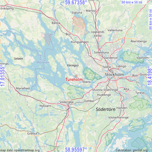
Tureholm GPS coordinates[2]
59° 19' 0.012" North, 17° 43' 0.012" East
| Map corner | latitude | longitude |
|---|---|---|
| Upper-left | 59.67358°, | 17.01355° |
| Center: | 59.31667°, | 17.71667° |
| Lower-right: | 58.95597°, | 18.4198° |
| Map W x H: | 79.8×79.8 km | = 49.6×49.6mi |
| max Lat: | 67.85572° ⇑39.6% North |
| Tureholm: | 59.31667° |
| min Lat: | ⇓60.4% South 55.34337° |
| min Long | Tureholm | max Long |
| 11.1712° | 17.71667° | 24.13676° |
| W 81.7%⇐ | ⇒18.3% E |
Elevation
Elevation of Tureholm is 35 m = 115 ft, and this is 47.6 m = 156 ft below average elevation for this country.
| Max E: |
663 m = 2175 ft | 60.3% |
| Avg. | 82.6 m = 271 ft | |
| Tureholm | 35 m = 115 ft | |
Min E: |
-1 m = -3 ft | 39.7% |
See also: Sweden elevation on elevation.city.
Geographical zone
Tureholm is located in North temperate zone (between Tropic of Cancer and the Arctic Circle). Distance of this North polar circle is 805.8 km =500.7 mi to North.| Distance of | km | miles | from Tureholm |
|---|---|---|---|
| North Pole | 3411.7 | 2119.9 | to North |
| Arctic Circle | 805.8 | 500.7 | to North |
| Tropic Cancer | 3989.5 | 2479 | to South |
| Equator | 6595.4 | 4098.2 | to South |


Nearby cities:
15 places around Tureholm: (largest is in red/bold)
• Alby
12.1 km =7.5 mi,  139°
139°
• Bromma
12.9 km =8 mi,  78°
78°
• Ekeby
13.4 km =8.3 mi,  236°
236°
• Ekerö
6.1 km =3.8 mi,  117°
117°
• Eriksberg
10 km =6.2 mi,  145°
145°
• Fittja
11.1 km =6.9 mi,  132°
132°
• Kungsberga
11 km =6.8 mi,  333°
333°
• Parksidan
8.5 km =5.3 mi, 118°
• Rönninge
13 km =8.1 mi,  175°
175°
• Segeltorp
13 km =8.1 mi,  110°
110°
• Stenhamra
2.5 km =1.6 mi,  320°
320°
• Viksäter
10.2 km =6.3 mi,  214°
214°
• Vårby
11 km =6.8 mi, 120°
• Älvnäs
4.7 km =2.9 mi, 142°
• Ölsta
10 km =6.2 mi,  337°
337°
Sources, notices
• [Note1] Compared only with cities in Sweden existing in our database
• [Src1] Map data: © OpenStreetMap contributors (CC-BY-SA)
• [Src2] Other city data from geonames.org with taken over terms of usage.
• [Src3] Geographical zone / Annual Mean Temperature by Robert A. Rohde @ Wikipedia
