Tollarp1 geodata
Tollarp1 (Skåne) is a populated place; located in Sweden in Europe/Stockholm (GMT+2) time zone. With population of 3,170 people, there are 389 cities with bigger population in this country. Compared to other cities in Sweden, 89.1% of cities are located further ↑North; 59.6% of cities are located further →East and 84.8% of cities have higher elevation than Tollarp1. Note1


Tollarp1 GPS coordinates[2]
56° 10' 0.012" North, 14° 16' 59.988" East
| Map corner | latitude | longitude |
|---|---|---|
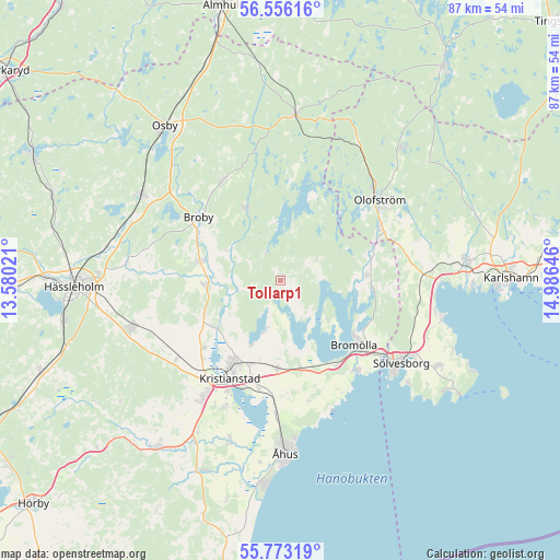
| Upper-left | 56.55616°, | 13.58021° |
| Center: | 56.16667°, | 14.28333° |
| Lower-right: | 55.77319°, | 14.98646° |
| Map W x H: | 87.1×87.1 km | = 54.1×54.1mi |
| max Lat: | 67.85572° ⇑89.1% North |
| Tollarp1: | 56.16667° |
| min Lat: | ⇓10.9% South 55.34337° |
| min Long | Tollarp1 | max Long |
| 11.1712° | 14.28333° | 24.13676° |
| W 40.4%⇐ | ⇒59.6% E |
Elevation
Elevation of Tollarp1 is 13 m = 43 ft, and this is 69.6 m = 228 ft below average elevation for this country.
| Max E: |
663 m = 2175 ft | 84.8% |
| Avg. | 82.6 m = 271 ft | |
| Tollarp1 | 13 m = 43 ft | |
Min E: |
-1 m = -3 ft | 15.2% |
See also: Sweden elevation on elevation.city.
Geographical zone
Tollarp1 is located in North temperate zone (between Tropic of Cancer and the Arctic Circle). Distance of this North polar circle is 1156 km =718.3 mi to North.| Distance of | km | miles | from Tollarp1 |
|---|---|---|---|
| North Pole | 3761.9 | 2337.5 | to North |
| Arctic Circle | 1156 | 718.3 | to North |
| Tropic Cancer | 3639.2 | 2261.3 | to South |
| Equator | 6245.1 | 3880.5 | to South |


Nearby cities:
15 places around Tollarp1: (largest is in red/bold)
• Arkelstorp
0.6 km =0.4 mi,  52°
52°
• Broby
16.1 km =10 mi,  307°
307°
• Bromölla
15.4 km =9.6 mi,  131°
131°
• Fjälkinge
13.7 km =8.5 mi,  182°
182°
• Färlöv
16.7 km =10.4 mi,  228°
228°
• Gualöv
15.4 km =9.6 mi,  147°
147°
• Hammar
17.2 km =10.7 mi,  193°
193°
• Hammarslund
17.4 km =10.8 mi,  198°
198°
• Hanaskog
11.8 km =7.3 mi,  266°
266°
• Hittarp
16.6 km =10.3 mi,  321°
321°
• Jämshög
16.2 km =10.1 mi,  62°
62°
• Knislinge
12.5 km =7.8 mi,  278°
278°
• Kristianstad
17.1 km =10.6 mi,  208°
208°
• Näsum
13.3 km =8.3 mi,  85°
85°
• Sibbhult
12.3 km =7.6 mi,  335°
335°
Sources, notices
• [Note1] Compared only with cities in Sweden existing in our database
• [Src1] Map data: © OpenStreetMap contributors (CC-BY-SA)
• [Src2] Other city data from geonames.org with taken over terms of usage.
• [Src3] Geographical zone / Annual Mean Temperature by Robert A. Rohde @ Wikipedia
