Tenhult geodata
Tenhult (Jönköping) is a populated place; located in Sweden in Europe/Stockholm (GMT+2) time zone. With population of 3,112 people, there are 396 cities with bigger population in this country. Compared to other cities in Sweden, 67.3% of cities are located further ↑North; 58.8% of cities are located further →East and 93.4% of cities have lower elevation than Tenhult. Note1
Administrative division(s):
- Level 1: Jönköping
- Level 2: Jönköpings Kommun
- Level 3: Rogberga-Öggestorp
- Level 4: Rogberga socken


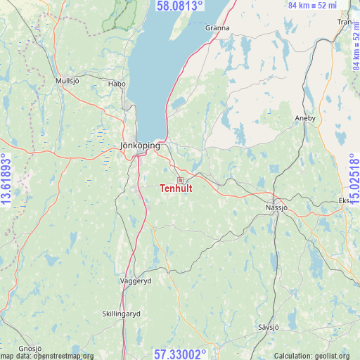
Tenhult GPS coordinates[2]
57° 42' 27.396" North, 14° 19' 19.38" East
| Map corner | latitude | longitude |
|---|---|---|
| Upper-left | 58.0813°, | 13.61893° |
| Center: | 57.70761°, | 14.32205° |
| Lower-right: | 57.33002°, | 15.02518° |
| Map W x H: | 83.5×83.5 km | = 51.9×51.9mi |
| max Lat: | 67.85572° ⇑67.3% North |
| Tenhult: | 57.70761° |
| min Lat: | ⇓32.7% South 55.34337° |
| min Long | Tenhult | max Long |
| 11.1712° | 14.32205° | 24.13676° |
| W 41.2%⇐ | ⇒58.8% E |
Elevation
Elevation of Tenhult is 230 m = 755 ft, and this is 147.4 m = 484 ft above average elevation for this country.
| Max E: |
663 m = 2175 ft | 6.6% |
| Tenhult | 230 m 755 ft | |
| Avg. | 82.6 m = 271 ft | |
Min E: |
-1 m = -3 ft | 93.4% |
See also: Sweden elevation on elevation.city.
Geographical zone
Tenhult is located in North temperate zone (between Tropic of Cancer and the Arctic Circle). Distance of this North polar circle is 984.7 km =611.9 mi to North.| Distance of | km | miles | from Tenhult |
|---|---|---|---|
| North Pole | 3590.6 | 2231.1 | to North |
| Arctic Circle | 984.7 | 611.9 | to North |
| Tropic Cancer | 3810.6 | 2367.8 | to South |
| Equator | 6416.5 | 3987 | to South |


Nearby cities:
15 places around Tenhult: (largest is in red/bold)
• Bankeryd
20.6 km =12.8 mi,  325°
325°
• Barnarp
8.6 km =5.3 mi,  267°
267°
• Forserum
8.6 km =5.3 mi,  95°
95°
• Hok
21.5 km =13.4 mi,  187°
187°
• Huskvarna
8.8 km =5.5 mi,  352°
352°
• Jönköping
12.8 km =8 mi,  309°
309°
• Kaxholmen
16.2 km =10.1 mi,  356°
356°
• Kortebo
15.8 km =9.8 mi,  319°
319°
• Lekeryd
8 km =5 mi,  35°
35°
• Malmbäck
16.8 km =10.4 mi,  150°
150°
• Nässjö
23.1 km =14.4 mi,  105°
105°
• Odensjö
9.3 km =5.8 mi,  276°
276°
• Ryssby
19.5 km =12.1 mi,  87°
87°
• Taberg
14.3 km =8.9 mi,  256°
256°
• Vaggeryd
25.5 km =15.8 mi,  203°
203°
Sources, notices
• [Note1] Compared only with cities in Sweden existing in our database
• [Src1] Map data: © OpenStreetMap contributors (CC-BY-SA)
• [Src2] Other city data from geonames.org with taken over terms of usage.
• [Src3] Geographical zone / Annual Mean Temperature by Robert A. Rohde @ Wikipedia
