Hok geodata
Hok (Jönköping) is a populated place; located in Sweden in Europe/Stockholm (GMT+2) time zone. With population of 658 people, there are 1111 cities with bigger population in this country. Compared to other cities in Sweden, 71.2% of cities are located further ↑North; 59.7% of cities are located further →East and 91.6% of cities have lower elevation than Hok. Note1
Administrative division(s):
- Level 1: Jönköping
- Level 2: Vaggeryds Kommun
- Level 3: Svenarum
- Level 4: Svenarum socken


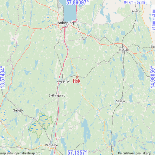
Hok GPS coordinates[2]
57° 30' 55.044" North, 14° 16' 38.856" East
| Map corner | latitude | longitude |
|---|---|---|
| Upper-left | 57.89097°, | 13.57434° |
| Center: | 57.51529°, | 14.27746° |
| Lower-right: | 57.1357°, | 14.98059° |
| Map W x H: | 84×84 km | = 52.2×52.2mi |
| max Lat: | 67.85572° ⇑71.2% North |
| Hok: | 57.51529° |
| min Lat: | ⇓28.8% South 55.34337° |
| min Long | Hok | max Long |
| 11.1712° | 14.27746° | 24.13676° |
| W 40.3%⇐ | ⇒59.7% E |
Elevation
Elevation of Hok is 216 m = 709 ft, and this is 133.4 m = 438 ft above average elevation for this country.
| Max E: |
663 m = 2175 ft | 8.4% |
| Hok | 216 m 709 ft | |
| Avg. | 82.6 m = 271 ft | |
Min E: |
-1 m = -3 ft | 91.6% |
See also: Sweden elevation on elevation.city.
Geographical zone
Hok is located in North temperate zone (between Tropic of Cancer and the Arctic Circle). Distance of this North polar circle is 1006.1 km =625.2 mi to North.| Distance of | km | miles | from Hok |
|---|---|---|---|
| North Pole | 3612 | 2244.4 | to North |
| Arctic Circle | 1006.1 | 625.2 | to North |
| Tropic Cancer | 3789.2 | 2354.5 | to South |
| Equator | 6395.1 | 3973.7 | to South |


Nearby cities:
15 places around Hok: (largest is in red/bold)
• Barnarp
21.8 km =13.5 mi,  344°
344°
• Bodafors
25.3 km =15.7 mi,  93°
93°
• Forserum
23.4 km =14.5 mi,  28°
28°
• Lekeryd
28.9 km =18 mi,  14°
14°
• Linneryd
14.9 km =9.3 mi,  210°
210°
• Malmbäck
12.9 km =8 mi,  58°
58°
• Nässjö
29.3 km =18.2 mi, 58°
• Odensjö
23.3 km =14.5 mi, 343°
• Skillingaryd
14.5 km =9 mi,  229°
229°
• Stockaryd
29 km =18 mi,  139°
139°
• Sävsjö
26.2 km =16.3 mi,  118°
118°
• Taberg
21.2 km =13.2 mi,  328°
328°
• Tenhult
21.5 km =13.4 mi, 7°
• Vaggeryd
7.9 km =4.9 mi,  256°
256°
• Vrigstad
21.6 km =13.4 mi,  148°
148°
Sources, notices
• [Note1] Compared only with cities in Sweden existing in our database
• [Src1] Map data: © OpenStreetMap contributors (CC-BY-SA)
• [Src2] Other city data from geonames.org with taken over terms of usage.
• [Src3] Geographical zone / Annual Mean Temperature by Robert A. Rohde @ Wikipedia
