Jönköping geodata
Jönköping is a seat of a first-order administrative division; located in Sweden in Europe/Stockholm (GMT+2) time zone. With population of 93,797 people, there are 10 cities with bigger population in this country. Compared to other cities in Sweden, 64.9% of cities are located further ↑North; 61.6% of cities are located further →East and 70.5% of cities have lower elevation than Jönköping. Note1


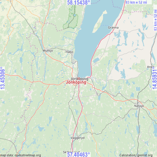
Jönköping GPS coordinates[2]
57° 46' 53.22" North, 14° 9' 22.248" East
| Map corner | latitude | longitude |
|---|---|---|
| Upper-left | 58.15438°, | 13.45306° |
| Center: | 57.78145°, | 14.15618° |
| Lower-right: | 57.40463°, | 14.85931° |
| Map W x H: | 83.4×83.4 km | = 51.8×51.8mi |
| max Lat: | 67.85572° ⇑64.9% North |
| Jönköping: | 57.78145° |
| min Lat: | ⇓35.1% South 55.34337° |
| min Long | Jönköping | max Long |
| 11.1712° | 14.15618° | 24.13676° |
| W 38.4%⇐ | ⇒61.6% E |
Elevation
Elevation of Jönköping is 100 m = 328 ft, and this is 17.4 m = 57 ft above average elevation for this country.
| Max E: |
663 m = 2175 ft | 29.5% |
| Jönköping | 100 m 328 ft | |
| Avg. | 82.6 m = 271 ft | |
Min E: |
-1 m = -3 ft | 70.5% |
See also: Jönköping elevation on elevation.city.
Geographical zone
Jönköping is located in North temperate zone (between Tropic of Cancer and the Arctic Circle). Distance of this North polar circle is 976.5 km =606.8 mi to North.| Distance of | km | miles | from Jönköping |
|---|---|---|---|
| North Pole | 3582.4 | 2226 | to North |
| Arctic Circle | 976.5 | 606.8 | to North |
| Tropic Cancer | 3818.8 | 2372.9 | to South |
| Equator | 6424.7 | 3992.1 | to South |


Nearby cities:
15 places around Jönköping: (largest is in red/bold)
• Bankeryd
9 km =5.6 mi,  347°
347°
• Barnarp
8.7 km =5.4 mi,  171°
171°
• Bottnaryd
19.6 km =12.2 mi,  266°
266°
• Forserum
20.5 km =12.7 mi,  116°
116°
• Habo
15.3 km =9.5 mi,  341°
341°
• Hestra
29.4 km =18.3 mi,  59°
59°
• Huskvarna
8.7 km =5.4 mi,  86°
86°
• Kaxholmen
11.9 km =7.4 mi,  47°
47°
• Kortebo
3.9 km =2.4 mi, 354°
• Lekeryd
14.5 km =9 mi,  96°
96°
• Malmbäck
29.1 km =18.1 mi,  141°
141°
• Mullsjö
22.3 km =13.9 mi,  312°
312°
• Odensjö
7.2 km =4.5 mi,  175°
175°
• Taberg
12.3 km =7.6 mi,  199°
199°
• Tenhult
12.8 km =8 mi,  129°
129°
Sources, notices
• [Note1] Compared only with cities in Sweden existing in our database
• [Src1] Map data: © OpenStreetMap contributors (CC-BY-SA)
• [Src2] Other city data from geonames.org with taken over terms of usage.
• [Src3] Geographical zone / Annual Mean Temperature by Robert A. Rohde @ Wikipedia
