Kortebo geodata
Kortebo (Jönköping) is a populated place; located in Sweden in Europe/Stockholm (GMT+2) time zone. With population of 512 people, there are 1297 cities with bigger population in this country. Compared to other cities in Sweden, 63.9% of cities are located further ↑North; 62.1% of cities are located further →East and 74.8% of cities have lower elevation than Kortebo. Note1


Kortebo GPS coordinates[2]
57° 49' 0.012" North, 14° 9' 0" East
| Map corner | latitude | longitude |
|---|---|---|
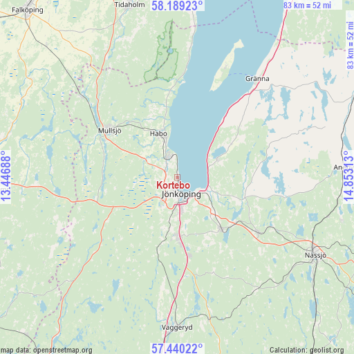
| Upper-left | 58.18923°, | 13.44688° |
| Center: | 57.81667°, | 14.15° |
| Lower-right: | 57.44022°, | 14.85313° |
| Map W x H: | 83.3×83.3 km | = 51.8×51.8mi |
| max Lat: | 67.85572° ⇑63.9% North |
| Kortebo: | 57.81667° |
| min Lat: | ⇓36.1% South 55.34337° |
| min Long | Kortebo | max Long |
| 11.1712° | 14.15° | 24.13676° |
| W 37.9%⇐ | ⇒62.1% E |
Elevation
Elevation of Kortebo is 119 m = 390 ft, and this is 36.4 m = 119 ft above average elevation for this country.
| Max E: |
663 m = 2175 ft | 25.2% |
| Kortebo | 119 m 390 ft | |
| Avg. | 82.6 m = 271 ft | |
Min E: |
-1 m = -3 ft | 74.8% |
See also: Sweden elevation on elevation.city.
Geographical zone
Kortebo is located in North temperate zone (between Tropic of Cancer and the Arctic Circle). Distance of this North polar circle is 972.6 km =604.3 mi to North.| Distance of | km | miles | from Kortebo |
|---|---|---|---|
| North Pole | 3578.5 | 2223.6 | to North |
| Arctic Circle | 972.6 | 604.3 | to North |
| Tropic Cancer | 3822.7 | 2375.3 | to South |
| Equator | 6428.6 | 3994.5 | to South |


Nearby cities:
15 places around Kortebo: (largest is in red/bold)
• Bankeryd
5.1 km =3.2 mi,  342°
342°
• Barnarp
12.6 km =7.8 mi,  172°
172°
• Bottnaryd
19.8 km =12.3 mi,  255°
255°
• Forserum
22.8 km =14.2 mi,  124°
124°
• Gränna
29.1 km =18.1 mi,  40°
40°
• Habo
11.5 km =7.1 mi, 337°
• Hestra
27.9 km =17.3 mi,  66°
66°
• Huskvarna
9.6 km =6 mi,  110°
110°
• Jönköping
3.9 km =2.4 mi, 174°
• Kaxholmen
10 km =6.2 mi, 65°
• Lekeryd
15.8 km =9.8 mi, 110°
• Mullsjö
19.6 km =12.2 mi,  304°
304°
• Odensjö
11.2 km =7 mi, 174°
• Taberg
15.9 km =9.9 mi,  193°
193°
• Tenhult
15.8 km =9.8 mi,  139°
139°
Sources, notices
• [Note1] Compared only with cities in Sweden existing in our database
• [Src1] Map data: © OpenStreetMap contributors (CC-BY-SA)
• [Src2] Other city data from geonames.org with taken over terms of usage.
• [Src3] Geographical zone / Annual Mean Temperature by Robert A. Rohde @ Wikipedia
