Svarte geodata
Svarte (Skåne) is a populated place; located in Sweden in Europe/Stockholm (GMT+2) time zone. With population of 921 people, there are 867 cities with bigger population in this country. Compared to other cities in Sweden, 99.1% of cities are located further ↑North; 67.7% of cities are located further →East and 70% of cities have higher elevation than Svarte. Note1
Administrative division(s):
- Level 1: Skåne
- Level 2: Ystads Kommun
- Level 3: Ljunits
- Level 4: Balkåkra socken


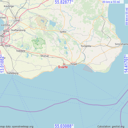
Svarte GPS coordinates[2]
55° 25' 54.624" North, 13° 42' 50.184" East
| Map corner | latitude | longitude |
|---|---|---|
| Upper-left | 55.82877°, | 13.01082° |
| Center: | 55.43184°, | 13.71394° |
| Lower-right: | 55.03088°, | 14.41707° |
| Map W x H: | 88.7×88.7 km | = 55.1×55.1mi |
| max Lat: | 67.85572° ⇑99.1% North |
| Svarte: | 55.43184° |
| min Lat: | ⇓0.9% South 55.34337° |
| min Long | Svarte | max Long |
| 11.1712° | 13.71394° | 24.13676° |
| W 32.3%⇐ | ⇒67.7% E |
Elevation
Elevation of Svarte is 25 m = 82 ft, and this is 57.6 m = 189 ft below average elevation for this country.
| Max E: |
663 m = 2175 ft | 70% |
| Avg. | 82.6 m = 271 ft | |
| Svarte | 25 m = 82 ft | |
Min E: |
-1 m = -3 ft | 30% |
See also: Sweden elevation on elevation.city.
Geographical zone
Svarte is located in North temperate zone (between Tropic of Cancer and the Arctic Circle). Distance of this North polar circle is 1237.7 km =769.1 mi to North.| Distance of | km | miles | from Svarte |
|---|---|---|---|
| North Pole | 3843.6 | 2388.3 | to North |
| Arctic Circle | 1237.7 | 769.1 | to North |
| Tropic Cancer | 3557.5 | 2210.5 | to South |
| Equator | 6163.4 | 3829.8 | to South |


Nearby cities:
15 places around Svarte: (largest is in red/bold)
• Abbekås
8 km =5 mi,  243°
243°
• Anderslöv
24.9 km =15.5 mi,  271°
271°
• Blentarp
18.3 km =11.4 mi,  336°
336°
• Idala
24.9 km =15.5 mi,  327°
327°
• Klagstorp
21.8 km =13.5 mi,  258°
258°
• Köpingebro
14.2 km =8.8 mi,  79°
79°
• Löderup
25.4 km =15.8 mi,  89°
89°
• Rydsgård
9.1 km =5.7 mi,  299°
299°
• Sjöbo
22.2 km =13.8 mi,  358°
358°
• Skivarp
9.4 km =5.8 mi, 259°
• Skurup
14.3 km =8.9 mi,  291°
291°
• Smygehamn
23.9 km =14.9 mi,  245°
245°
• Tomelilla
19.6 km =12.2 mi,  50°
50°
• Veberöd
26.7 km =16.6 mi, 327°
• Ystad
6.7 km =4.2 mi, 92°
Sources, notices
• [Note1] Compared only with cities in Sweden existing in our database
• [Src1] Map data: © OpenStreetMap contributors (CC-BY-SA)
• [Src2] Other city data from geonames.org with taken over terms of usage.
• [Src3] Geographical zone / Annual Mean Temperature by Robert A. Rohde @ Wikipedia
